IMAGES TAKEN NEAR TO
Wolfscastle, HAVERFORDWEST, SA62 5DY
Introduction
This page details the photographs taken nearby to SA62 5DY by members of the Geograph project.
The Geograph project started in 2005 with the aim of publishing, organising and preserving representative images for every square kilometre of Great Britain, Ireland and the Isle of Man.

There are currently over 7.5m images from over14,400 individuals and you can help contribute to the project by visiting https://www.geograph.org.uk
Image Map (Loading...)


Getting Data...Please wait
Leaflet Map data © OpenStreetMap
Images are licensed for reuse under creativecommons.org/licenses/by-sa/2.0
Notes
- Clicking on the map will re-center to the selected point.
- The higher the marker number, the further away the image location is from the centre of the postcode.
Image Listing (1 Images Found)
Images are licensed for reuse under creativecommons.org/licenses/by-sa/2.0
Image
Details
Distance
1
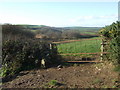
Pasture land with gate
East of Wolfscastle a public right-of-way crosses the fields in the direction of Rinaston. The route was not well marked but appeared to skirt the boggy valley (left) of a small stream.
This unusual gate would not deter sheep but it is mainly dairy farming here.
Image: © Natasha Ceridwen de Chroustchoff
Taken: 22 Nov 2007
0.24 miles