IMAGES TAKEN NEAR TO
Wolfscastle, HAVERFORDWEST, SA62 5DX
Introduction
This page details the photographs taken nearby to SA62 5DX by members of the Geograph project.
The Geograph project started in 2005 with the aim of publishing, organising and preserving representative images for every square kilometre of Great Britain, Ireland and the Isle of Man.

There are currently over 7.5m images from over14,400 individuals and you can help contribute to the project by visiting https://www.geograph.org.uk
Image Map
Images are licensed for reuse under creativecommons.org/licenses/by-sa/2.0
Notes
- Clicking on the map will re-center to the selected point.
- The higher the marker number, the further away the image location is from the centre of the postcode.
Image Listing (3 Images Found)
Images are licensed for reuse under creativecommons.org/licenses/by-sa/2.0
Image
Details
Distance
1
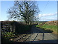
Road west towards Wolfscastle
Pastureland on either side, a few trees and a gentle decline towards the valley of the Cleddau Wen.
Image: © Natasha Ceridwen de Chroustchoff
Taken: 22 Nov 2007
0.11 miles
2
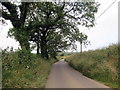
Heol fach i Gas-blaidd / Minor road to Wolf's Castle
Heol fach yn mynd i gyfeiriad Cas-blaidd.
A minor road heading towards Wolf's Castle.
Image: © Alan Richards
Taken: 7 Jul 2019
0.12 miles
3
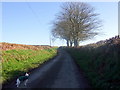
East from Wolfscastle
A quiet, high-banked road leads towards Ambleston.
Image: © Natasha Ceridwen de Chroustchoff
Taken: 22 Nov 2007
0.15 miles