IMAGES TAKEN NEAR TO
Wiston, HAVERFORDWEST, SA62 4PJ
Introduction
This page details the photographs taken nearby to SA62 4PJ by members of the Geograph project.
The Geograph project started in 2005 with the aim of publishing, organising and preserving representative images for every square kilometre of Great Britain, Ireland and the Isle of Man.

There are currently over 7.5m images from over14,400 individuals and you can help contribute to the project by visiting https://www.geograph.org.uk
Image Map
Images are licensed for reuse under creativecommons.org/licenses/by-sa/2.0
Notes
- Clicking on the map will re-center to the selected point.
- The higher the marker number, the further away the image location is from the centre of the postcode.
Image Listing (3 Images Found)
Images are licensed for reuse under creativecommons.org/licenses/by-sa/2.0
Image
Details
Distance
1
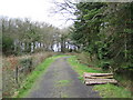
Wiston Wood
On the forestry track a few metres off the lane from Haverfordwest to Llawhaden.
Image: © John Winterbottom
Taken: 23 Apr 2006
0.15 miles
2
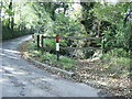
Stream at the bottom of Conkland Hill
Looking along the trees at the bottom of Conkland Hill, the stream becomes Fenton Brook further along its route and eventually flows into the Western Cleddau at Haverfordwest.
Image: © Martyn Harries
Taken: 10 Oct 2010
0.22 miles
3
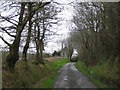
Woodlands
Smallholding on the lane towards Llawhaden.
Image: © John Winterbottom
Taken: 23 Apr 2006
0.23 miles