IMAGES TAKEN NEAR TO
Sardis, HAVERFORDWEST, SA62 4NS
Introduction
This page details the photographs taken nearby to SA62 4NS by members of the Geograph project.
The Geograph project started in 2005 with the aim of publishing, organising and preserving representative images for every square kilometre of Great Britain, Ireland and the Isle of Man.

There are currently over 7.5m images from over14,400 individuals and you can help contribute to the project by visiting https://www.geograph.org.uk
Image Map
Images are licensed for reuse under creativecommons.org/licenses/by-sa/2.0
Notes
- Clicking on the map will re-center to the selected point.
- The higher the marker number, the further away the image location is from the centre of the postcode.
Image Listing (13 Images Found)
Images are licensed for reuse under creativecommons.org/licenses/by-sa/2.0
Image
Details
Distance
1
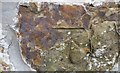
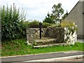
Ordnance Survey Cut Mark
This OS cut mark can be found on the SW face of the barn NE side of the road. It marks a point 81.777m above mean sea level.
Image: © Adrian Dust
Taken: 16 Apr 2017
0.03 miles
2
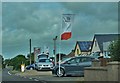
Seat Car Dealer At Sardis
On the Haverfordwest to Burton road
Image: © Deborah Tilley
Taken: 27 Jun 2015
0.07 miles
3
Bungalow on Ashdale Lane
"Deu Kerens" holiday bungalow
Image: © Mike Graham
Taken: 28 Sep 2004
0.09 miles
4
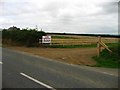
More diversification.
Nash Mountain caravan and camping site at Sardis.
Image: © Shaun Butler
Taken: 8 Aug 2008
0.12 miles
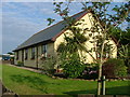
6
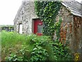
The 'Facilities' at Sardis Baptist church.
The sign says 'ladies' - no idea where the gents are...
Image: © Shaun Butler
Taken: 8 Aug 2008
0.21 miles
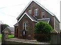
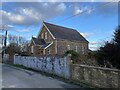
9
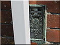
Ordnance Survey Flush Bracket S0590
This can be found on the wall of Sardis Chapel.
For more detail see : http://www.bench-marks.org.uk/bm20628
Image: © Peter Wood
Taken: 19 May 2013
0.22 miles
10
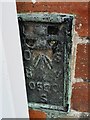
Ordnance Survey Flush Bracket (S0590)
This OS Flush Bracket can be found on the SW face of the chapel. It marks a point 75.190m above mean sea level.
Image: © Adrian Dust
Taken: 16 Apr 2017
0.22 miles