IMAGES TAKEN NEAR TO
Freystrop, HAVERFORDWEST, SA62 4NL
Introduction
This page details the photographs taken nearby to SA62 4NL by members of the Geograph project.
The Geograph project started in 2005 with the aim of publishing, organising and preserving representative images for every square kilometre of Great Britain, Ireland and the Isle of Man.

There are currently over 7.5m images from over14,400 individuals and you can help contribute to the project by visiting https://www.geograph.org.uk
Image Map
Images are licensed for reuse under creativecommons.org/licenses/by-sa/2.0
Notes
- Clicking on the map will re-center to the selected point.
- The higher the marker number, the further away the image location is from the centre of the postcode.
Image Listing (5 Images Found)
Images are licensed for reuse under creativecommons.org/licenses/by-sa/2.0
Image
Details
Distance
3
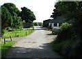
"Moorview" reflected in a hedgerow
Absolutely necessary for getting out of the drive to East Moor: uphill and on a blind corner.
Note the strange figure in the orange shirt.
Image: © Colin Bell
Taken: 14 Jun 2008
0.08 miles
4
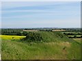
Hillock and oil seed rape
A few fields have crops, rather than grazing: oil seed rape here, and something else on the two fields in the distance.
Image: © Colin Bell
Taken: 14 Jun 2008
0.15 miles
5
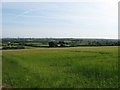
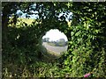
Fields with views to the oil refineries
The relatively poor soils are mostly suitable only for grazing, as can be seen. A generally flat area gives good views towards Milford Haven and beyond including the two oil refineries and the Castlemartin peninsula.
Image: © Colin Bell
Taken: 14 Jun 2008
0.20 miles