IMAGES TAKEN NEAR TO
Crundale, HAVERFORDWEST, SA62 4DU
Introduction
This page details the photographs taken nearby to SA62 4DU by members of the Geograph project.
The Geograph project started in 2005 with the aim of publishing, organising and preserving representative images for every square kilometre of Great Britain, Ireland and the Isle of Man.

There are currently over 7.5m images from over14,400 individuals and you can help contribute to the project by visiting https://www.geograph.org.uk
Image Map
Images are licensed for reuse under creativecommons.org/licenses/by-sa/2.0
Notes
- Clicking on the map will re-center to the selected point.
- The higher the marker number, the further away the image location is from the centre of the postcode.
Image Listing (3 Images Found)
Images are licensed for reuse under creativecommons.org/licenses/by-sa/2.0
Image
Details
Distance
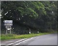
1
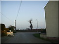
Road junction at Poyston Cross
The minor road from Haverfordwest (Withybush) Airfield makes a T-junction with the B4329 at Poyston Cross.
Image: © Martyn Harries
Taken: 5 Mar 2011
0.03 miles
2
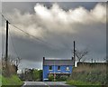
House At Poyston Cross
On the Haverfordwest to Cardigan road
Image: © Deborah Tilley
Taken: 2 Jan 2016
0.03 miles