IMAGES TAKEN NEAR TO
Crundale, HAVERFORDWEST, SA62 4DE
Introduction
This page details the photographs taken nearby to SA62 4DE by members of the Geograph project.
The Geograph project started in 2005 with the aim of publishing, organising and preserving representative images for every square kilometre of Great Britain, Ireland and the Isle of Man.

There are currently over 7.5m images from over14,400 individuals and you can help contribute to the project by visiting https://www.geograph.org.uk
Image Map (Loading...)


Getting Data...Please wait
Leaflet Map data © OpenStreetMap
Images are licensed for reuse under creativecommons.org/licenses/by-sa/2.0
Notes
- Clicking on the map will re-center to the selected point.
- The higher the marker number, the further away the image location is from the centre of the postcode.
Image Listing (2 Images Found)
Images are licensed for reuse under creativecommons.org/licenses/by-sa/2.0
Image
Details
Distance
1
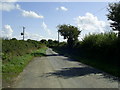
Passing place, near Crundale
A passing place on a single track road approaching the junction with the B4329 near Crundale.
Image: © Martyn Harries
Taken: 27 Aug 2010
0.05 miles
2
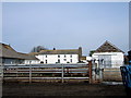
Poyston West
Dairy farm, one of many in this area.
Image: © Natasha Ceridwen de Chroustchoff
Taken: 21 Apr 2007
0.21 miles