IMAGES TAKEN NEAR TO
Rudbaxton, HAVERFORDWEST, SA62 4BY
Introduction
This page details the photographs taken nearby to SA62 4BY by members of the Geograph project.
The Geograph project started in 2005 with the aim of publishing, organising and preserving representative images for every square kilometre of Great Britain, Ireland and the Isle of Man.

There are currently over 7.5m images from over14,400 individuals and you can help contribute to the project by visiting https://www.geograph.org.uk
Image Map (Loading...)


Getting Data...Please wait
Leaflet Map data © OpenStreetMap
Images are licensed for reuse under creativecommons.org/licenses/by-sa/2.0
Notes
- Clicking on the map will re-center to the selected point.
- The higher the marker number, the further away the image location is from the centre of the postcode.
Image Listing (6 Images Found)
Images are licensed for reuse under creativecommons.org/licenses/by-sa/2.0
Image
Details
Distance
1
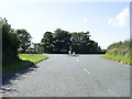
Road junction near Haverfordwest Airfield
The minor road from Poyston Cross makes a T-junction, part of a staggered crossroads, with the A40 near Haverfordwest (Withybush) Airfield.
Image: © Martyn Harries
Taken: 27 Aug 2010
0.12 miles
4
Haverfordwest (Withybush) Airport
A light aircraft is receiving some attention,
Image: © Jonathan Thacker
Taken: 28 Sep 2019
0.15 miles
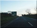
5
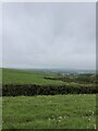
Countryside west of the A40
North of Tangiers
Image: © Eirian Evans
Taken: 1 May 2022
0.23 miles
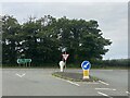
6

Haverfordwest: view across the airfield
The four-day Pembrokeshire County Show is drawing to a close and the airfield is obviously being used as a route for visitors or exhibitors. Here, we look out from stationary traffic on the A40, no doubt caused partly by the show traffic, as this afternoon's rain shows no signs of easing.
Image: © Chris Downer
Taken: 19 Aug 2010
0.24 miles