IMAGES TAKEN NEAR TO
Slebech, HAVERFORDWEST, SA62 4AX
Introduction
This page details the photographs taken nearby to SA62 4AX by members of the Geograph project.
The Geograph project started in 2005 with the aim of publishing, organising and preserving representative images for every square kilometre of Great Britain, Ireland and the Isle of Man.

There are currently over 7.5m images from over14,400 individuals and you can help contribute to the project by visiting https://www.geograph.org.uk
Image Map
Images are licensed for reuse under creativecommons.org/licenses/by-sa/2.0
Notes
- Clicking on the map will re-center to the selected point.
- The higher the marker number, the further away the image location is from the centre of the postcode.
Image Listing (5 Images Found)
Images are licensed for reuse under creativecommons.org/licenses/by-sa/2.0
Image
Details
Distance
1
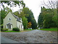
Lodge and entrance
To Slebech Park and Farm
Image: © Jonathan Billinger
Taken: 15 Oct 2008
0.09 miles
2
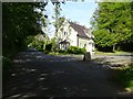
Lodge on Slebach Park
Lodge at the entrance to Slebach Park.
Image: © Philip Halling
Taken: 13 May 2019
0.10 miles
3
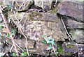
Ordnance Survey Cut Mark
This OS cut mark can be found on the SE roadside wall. It marks a point 61.863m above mean sea level.
Image: © Adrian Dust
Taken: 31 Mar 2017
0.10 miles
4
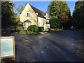
Lodge at Slebech Park
Lodge at the entrance to Slebech Park.
Image: © Alan Hughes
Taken: 11 Oct 2017
0.11 miles
5
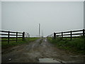
Entrance to Coldblow near The Rhos
This photograph shows a view of the entrance to Coldbow from the minor road between Slebech and The Rhos. Coldblow farm was many years ago part of the Picton Castle Estate.
Image: © Martyn Harries
Taken: 24 Jul 2010
0.20 miles