IMAGES TAKEN NEAR TO
Boulston, HAVERFORDWEST, SA62 4AG
Introduction
This page details the photographs taken nearby to SA62 4AG by members of the Geograph project.
The Geograph project started in 2005 with the aim of publishing, organising and preserving representative images for every square kilometre of Great Britain, Ireland and the Isle of Man.

There are currently over 7.5m images from over14,400 individuals and you can help contribute to the project by visiting https://www.geograph.org.uk
Image Map (Loading...)


Getting Data...Please wait
Leaflet Map data © OpenStreetMap
Images are licensed for reuse under creativecommons.org/licenses/by-sa/2.0
Notes
- Clicking on the map will re-center to the selected point.
- The higher the marker number, the further away the image location is from the centre of the postcode.
Image Listing (8 Images Found)
Images are licensed for reuse under creativecommons.org/licenses/by-sa/2.0
Image
Details
Distance


4
Western Cleddau
The Western Cleddau estuary viewed from Hanton Bridge.
Image: © Philip Halling
Taken: 13 May 2019
0.09 miles
5
Ordnance Survey Rivet
This OS rivet can be found on a concrete cylindrical block now on its side. It marks a point 15.345m above mean sea level.
Image: © Adrian Dust
Taken: 16 Apr 2017
0.11 miles
6
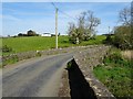
Hanton Farm From The Road
Situated just outside the village of Uzmaston
Image: © Deborah Tilley
Taken: 15 Feb 2015
0.14 miles
7
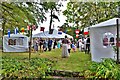
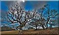
Wedding Party
A wonderful autumn wedding
Image: © Deborah Tilley
Taken: 13 Sep 2014
0.17 miles
8
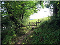
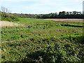
Llwybr ger Ffarm Fernhill / Path near Fernhill Farm
Llwybr cyhoeddus ar lan Afon Cleddau Wen ger Ffarm Fernhill.
A public footpath above Cleddau Wen River near Fernhill Farm.
Image: © Alan Richards
Taken: 7 Sep 2016
0.25 miles