IMAGES TAKEN NEAR TO
Walton West, Little Haven, HAVERFORDWEST, SA62 3UA
Introduction
This page details the photographs taken nearby to SA62 3UA by members of the Geograph project.
The Geograph project started in 2005 with the aim of publishing, organising and preserving representative images for every square kilometre of Great Britain, Ireland and the Isle of Man.

There are currently over 7.5m images from over14,400 individuals and you can help contribute to the project by visiting https://www.geograph.org.uk
Image Map
Images are licensed for reuse under creativecommons.org/licenses/by-sa/2.0
Notes
- Clicking on the map will re-center to the selected point.
- The higher the marker number, the further away the image location is from the centre of the postcode.
Image Listing (15 Images Found)
Images are licensed for reuse under creativecommons.org/licenses/by-sa/2.0
Image
Details
Distance
1
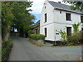
The Old Schoolhouse
Long disused as a school; I've been unable to track any information down on this place.
Image: © Richard Law
Taken: 23 Aug 2014
0.01 miles
2
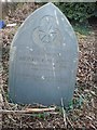
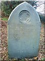
Pawlett family graves at Walton West
Recently revealed. Pawlett is a rare name in Pembrokeshire and originated in Somerset. All the Pawlett's here are related.
Image: © Deborah Tilley
Taken: 9 Jan 2009
0.01 miles
5
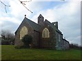
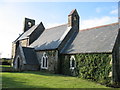
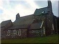
The church
It is unusual in this part of the world to see the stained glass windows protected.
Image: © Deborah Tilley
Taken: 9 Jan 2009
0.03 miles
6
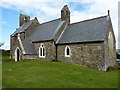
All Saints, Walton West
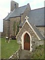
A tiny but active west Pembrokeshire village church.
Image: © Richard Law
Taken: 23 Aug 2014
0.03 miles
7
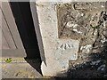
Ordnance Survey Cut Mark
This OS cut mark can be found on the porch of All Saints Church. It marks a point 51.984m above mean sea level.
Image: © Adrian Dust
Taken: 2 Oct 2022
0.03 miles
8
The church at Walton West
In an amazing setting with views to Broad Haven in the distance. It is still in use with a regular congregation. The graveyard has recently been cleared (by my husband!) and has uncovered many graves unseen for a long time. Good to see flowers there again!
Image: © Deborah Tilley
Taken: 9 Jan 2009
0.03 miles
9
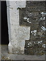
OS benchmark - Walton West church
A clear OS cutmark on one of the stones forming the doorway of the church porch; originally levelled at 51.984m above Ordnance Datum Newlyn.
Image: © Richard Law
Taken: 23 Aug 2014
0.03 miles