IMAGES TAKEN NEAR TO
Grove Road, HAVERFORDWEST, SA62 3TG
Introduction
This page details the photographs taken nearby to Grove Road, SA62 3TG by members of the Geograph project.
The Geograph project started in 2005 with the aim of publishing, organising and preserving representative images for every square kilometre of Great Britain, Ireland and the Isle of Man.

There are currently over 7.5m images from over14,400 individuals and you can help contribute to the project by visiting https://www.geograph.org.uk
Image Map (Loading...)


Getting Data...Please wait
Leaflet Map data © OpenStreetMap
Images are licensed for reuse under creativecommons.org/licenses/by-sa/2.0
Notes
- Clicking on the map will re-center to the selected point.
- The higher the marker number, the further away the image location is from the centre of the postcode.
Image Listing (4 Images Found)
Images are licensed for reuse under creativecommons.org/licenses/by-sa/2.0
Image
Details
Distance
2
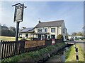
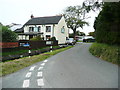
The Brook Inn
Public House in St Ishmael’s.
Image: © Alan Hughes
Taken: 19 Apr 2021
0.05 miles
3
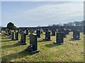
St Ishmael?s cemetery
Cemetery in the village of St Ishmael.
Image: © Alan Hughes
Taken: 19 Apr 2021
0.18 miles
4
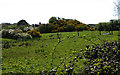
Motte
The Motte to the north of St.Ishmael's.
Image: © Dara Jasumani
Taken: 27 Apr 2006
0.19 miles