IMAGES TAKEN NEAR TO
Dale, HAVERFORDWEST, SA62 3RL
Introduction
This page details the photographs taken nearby to SA62 3RL by members of the Geograph project.
The Geograph project started in 2005 with the aim of publishing, organising and preserving representative images for every square kilometre of Great Britain, Ireland and the Isle of Man.

There are currently over 7.5m images from over14,400 individuals and you can help contribute to the project by visiting https://www.geograph.org.uk
Image Map (Loading...)


Getting Data...Please wait
Leaflet Map data © OpenStreetMap
Images are licensed for reuse under creativecommons.org/licenses/by-sa/2.0
Notes
- Clicking on the map will re-center to the selected point.
- The higher the marker number, the further away the image location is from the centre of the postcode.
Image Listing (17 Images Found)
Images are licensed for reuse under creativecommons.org/licenses/by-sa/2.0
Image
Details
Distance
2
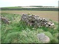
Ruined wall beside the coast path, Dale
Was the opening for sheep? Whatever its original purpose, anything can pass now.
Image: © David Smith
Taken: 14 Sep 2009
0.09 miles
3
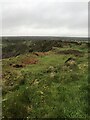
Unstable clifftop near Iron Point
Just west of the coast path
Image: © Eirian Evans
Taken: 1 May 2022
0.12 miles
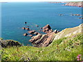
4
Ger / Near Iron Point
Creigiau y mor ger Iron Point.
Sea rocks near Iron Point.
Image: © Alan Richards
Taken: 6 Nov 2011
0.14 miles
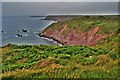
5
Iron Point
Lots of craggy rocks in the sea here
Image: © Eirian Evans
Taken: 1 May 2022
0.16 miles
6
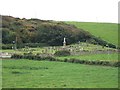
Dale cemetery
The impressive white statue is the village war memorial. Five men from Dale are named from the First World War and one from the second. To the left of the statue is a grave plot for eight unknown victims of a Japanese ship that was torpedoed in 1918, and whose bodies were washed up on the coast here.
Image: © David Smith
Taken: 14 Sep 2009
0.18 miles
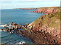
7
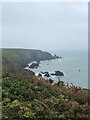
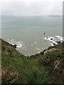
Iron Point
Looking down the cliffside to the jagged sandstone rocks of Iron Point. On the horizon, on the right is the coastline of The Marloes, Gateholm Island and behind it Skomer Island. Over to the left is Skokholm Island.
Image: © Tony Atkin
Taken: 21 Jun 2014
0.20 miles
8
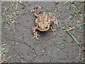
Another walker on the Coast Path
A toad coming to meet me on a particularly wet morning
Image: © Eirian Evans
Taken: 1 May 2022
0.21 miles
9
View down a gully
Looking down to the rocks by Iron Point. On the horizon, on the right is the coastline of the Marloes, Gateholm Island and behind it Skomer Island. Over to the left is Skokholm Island.
Image: © Eirian Evans
Taken: 1 May 2022
0.22 miles
10
Great Castle Head Fort
It appears that much has fallen into the sea from this promontory fort
Image: © Deborah Tilley
Taken: 20 Jun 2015
0.22 miles