IMAGES TAKEN NEAR TO
Dale, HAVERFORDWEST, SA62 3QZ
Introduction
This page details the photographs taken nearby to SA62 3QZ by members of the Geograph project.
The Geograph project started in 2005 with the aim of publishing, organising and preserving representative images for every square kilometre of Great Britain, Ireland and the Isle of Man.

There are currently over 7.5m images from over14,400 individuals and you can help contribute to the project by visiting https://www.geograph.org.uk
Image Map (Loading...)


Getting Data...Please wait
Leaflet Map data © OpenStreetMap
Images are licensed for reuse under creativecommons.org/licenses/by-sa/2.0
Notes
- Clicking on the map will re-center to the selected point.
- The higher the marker number, the further away the image location is from the centre of the postcode.
Image Listing (64 Images Found)
Images are licensed for reuse under creativecommons.org/licenses/by-sa/2.0
Image
Details
Distance
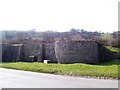
2
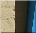
Ordnance Survey Cut Mark
This OS cut mark can be found on the stone building east side of the road. It marks a point 16.827m above mean sea level.
Image: © Adrian Dust
Taken: 2 Oct 2022
0.04 miles

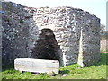
10
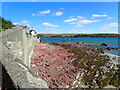
Black Rock, Dale
Looks to me that it should be called Red Rock!
Image: © Eirian Evans
Taken: 30 Aug 2022
0.06 miles