IMAGES TAKEN NEAR TO
Hillcroft, HAVERFORDWEST, SA62 3QB
Introduction
This page details the photographs taken nearby to Hillcroft, SA62 3QB by members of the Geograph project.
The Geograph project started in 2005 with the aim of publishing, organising and preserving representative images for every square kilometre of Great Britain, Ireland and the Isle of Man.

There are currently over 7.5m images from over14,400 individuals and you can help contribute to the project by visiting https://www.geograph.org.uk
Image Map
Images are licensed for reuse under creativecommons.org/licenses/by-sa/2.0
Notes
- Clicking on the map will re-center to the selected point.
- The higher the marker number, the further away the image location is from the centre of the postcode.
Image Listing (31 Images Found)
Images are licensed for reuse under creativecommons.org/licenses/by-sa/2.0
Image
Details
Distance
1
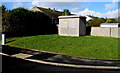
Hillcroft electricity substation, Johnston
The Western Power Distribution electricity substation identifier is HILLCROFT JOHNSTON S/S 603759.
Image: © Jaggery
Taken: 18 Feb 2016
0.01 miles
2
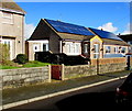
Rooftop solar panels, Hillcroft, Johnston
Viewed in February 2016. There were no solar panels here in a July 2009 Google Earth Street View.
Image: © Jaggery
Taken: 18 Feb 2016
0.03 miles
3
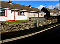
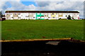
Hillcroft bungalows, Johnston
Hillcroft is an area of houses south of Langford Road.
Image: © Jaggery
Taken: 18 Feb 2016
0.03 miles
4
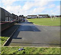
West along Hillcroft, Johnston
Housing in the east of Johnston.
Image: © Jaggery
Taken: 18 Feb 2016
0.04 miles
5
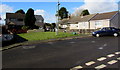
Long row of houses, Fair View, Johnston
The row extends for 60 metres (nearly 200 feet). Viewed from Hillcroft.
Image: © Jaggery
Taken: 18 Feb 2016
0.05 miles
6
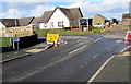
Gwyriad/Diversion sign facing Hillcroft, Johnston
In February 2016, all traffic must turn left here.
Out of shot on the right, http://www.geograph.org.uk/photo/4950699 temporary metal fencing blocks Langford Road.
Image: © Jaggery
Taken: 18 Feb 2016
0.06 miles
7
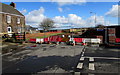
Blocked part of Langford Road, Johnston
In February 2016, temporary metal fencing blocks Langford Road at the Hillcroft junction opposite Langford Farm at the eastern edge of Johnston.
Image: © Jaggery
Taken: 18 Feb 2016
0.06 miles
8

Fair View, Johnston
Long row of houses extending for 60 metres (nearly 200 feet).
Image: © Jaggery
Taken: 18 Feb 2016
0.07 miles
9
Hillcroft houses, Johnston
Hillcroft is an area of houses south of Langford Road.
Image: © Jaggery
Taken: 18 Feb 2016
0.07 miles
10
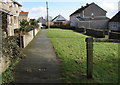
Path east towards Hillcroft, Johnston
From the edge of Johnston County Primary School.
Image: © Jaggery
Taken: 18 Feb 2016
0.09 miles