IMAGES TAKEN NEAR TO
Cranham Park, HAVERFORDWEST, SA62 3PU
Introduction
This page details the photographs taken nearby to Cranham Park, SA62 3PU by members of the Geograph project.
The Geograph project started in 2005 with the aim of publishing, organising and preserving representative images for every square kilometre of Great Britain, Ireland and the Isle of Man.

There are currently over 7.5m images from over14,400 individuals and you can help contribute to the project by visiting https://www.geograph.org.uk
Image Map (Loading...)


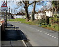
Getting Data...Please wait
Leaflet Map data © OpenStreetMap
Images are licensed for reuse under creativecommons.org/licenses/by-sa/2.0
Notes
- Clicking on the map will re-center to the selected point.
- The higher the marker number, the further away the image location is from the centre of the postcode.
Image Listing (109 Images Found)
Images are licensed for reuse under creativecommons.org/licenses/by-sa/2.0
Image
Details
Distance
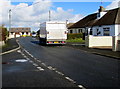
1
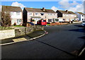
Greenhall Park towards Cranham Park, Johnston
Greenhall Park and Cranham Park are residential roads south of Langford Road.
Image: © Jaggery
Taken: 18 Feb 2016
0.02 miles
2
Junction of Greenhall Park and Cranham Park, Johnston
Greenhall Park and Cranham Park are residential roads south of Langford Road.
The triangular Ysgol/School warning sign on the left is on the approach to Johnston Primary School.
Image: © Jaggery
Taken: 18 Feb 2016
0.02 miles
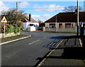
3
East along Greenhall Park, Johnston
Looking along Greenhall Park towards Cranham Park, both of which are areas of housing on the south side of Langford Road.
Image: © Jaggery
Taken: 18 Feb 2016
0.04 miles
4
Corner of Cranham Park and Langford Road, Johnston
Langford Road is ahead on the right. On the Cranham Park side of the corner are
a telecoms cabinet, postbox and bilingual (Welsh/English) Ysgol/School warning sign.
Image: © Jaggery
Taken: 18 Feb 2016
0.06 miles
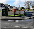
5
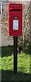
Queen Elizabeth II postbox on a Johnston corner
Located here. http://www.geograph.org.uk/photo/4950712
Image: © Jaggery
Taken: 18 Feb 2016
0.06 miles
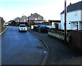
6
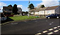
Hillcroft houses, Johnston
Hillcroft is an area of houses south of Langford Road.
Image: © Jaggery
Taken: 18 Feb 2016
0.06 miles
7
Cranham Park towards Langford Road, Johnston
Looking north along Cranham Park from the corner of Greenhall Park.
Cranham Park behind the camera leads to Johnston Primary School.
Image: © Jaggery
Taken: 18 Feb 2016
0.07 miles
8
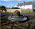
Circular metal bench, Greenhall Park, Johnston
Located near Johnston Primary School. Greenhall Park is a residential road.
Image: © Jaggery
Taken: 18 Feb 2016
0.07 miles
9
Warning sign - Hebryngwr/Patrol, Johnston
The bilingual (Welsh/English) sign faces Langford Road near Johnston County Primary School.
Image: © Jaggery
Taken: 18 Feb 2016
0.07 miles
10
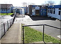
Entrance to Johnston County Primary School, Johnston
From the southern end of the road named Cranham Park.
Image: © Jaggery
Taken: 18 Feb 2016
0.07 miles