1
Junction of St Peter's Road and Station Road, Johnston
Viewed across the A4076 St Peter's Road. Station Road leads to Johnston
Business Park and Johnston railway station, a request stop on the West Wales Line.
Image: © Jaggery
Taken: 18 Feb 2016
0.01 miles
2
Johnston railway station name sign
The red and white name sign is on a pole on the corner of St Peter's Road and Station Road.
The station entrance http://www.geograph.org.uk/photo/4833481 is about 80 metres to the left.
Image: © Jaggery
Taken: 18 Feb 2016
0.02 miles
3
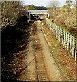
Brunel Trail at road bridge
The bridge carries St Peters Road, A4076, over the railway and the Trail.
Image: © M J Roscoe
Taken: 6 Jan 2024
0.02 miles
4
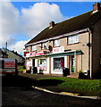
Johnston village noticeboard
On the corner of Glebelands and St Peter's Road. Help charity shop http://www.geograph.org.uk/photo/4833964 is on the left.
Image: © Jaggery
Taken: 18 Feb 2016
0.02 miles
5
Information boards, Station Road, Johnston
On the approach to the entrance http://www.geograph.org.uk/photo/4833481 to Johnston railway station, out of shot on the left.
Image: © Jaggery
Taken: 18 Feb 2016
0.02 miles
6
Johnston Business Park
Business park is rather a grand name for this collection of light industrial premises; eleven businesses are listed on the wonky sign - several are vehicle related but others include a brewery and dog grooming parlour. At the bottom of the slope is the entrance to Johnston's single platform railway station.
Image: © Stephen McKay
Taken: 14 May 2018
0.02 miles
7
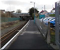
Johnston railway station
Unstaffed single-platform request stop station on the West Wales Line.
Next station ahead is Milford Haven, at the end of the line.
The bridge carries the A4076 St Peter's Road.
Image: © Jaggery
Taken: 18 Feb 2016
0.02 miles
8
Signs facing the southern end of Johnston railway station
The signs are on a girder on the A4076 St Peter's Road bridge. The Check AWS sign tells the train driver to confirm that the train's Automatic Warning System (AWS) is working. AWS is a safeguard against a driver failing to respond to a signal or misreading its aspect. If a driver fails to acknowledge an AWS warning within two seconds, brakes are automatically applied. Because this intervention occurs at the distant signal (the caution or amber aspect), AWS will stop the train before it reaches the stop (red) signal ahead.
Image: © Jaggery
Taken: 18 Feb 2016
0.02 miles
9
West Wales Line towards Johnston railway station
Viewed from Langford Road bridge http://www.geograph.org.uk/photo/4835820 looking NNW along the West Wales Line
towards the A4076 St Peter's Road bridge and Johnston railway station behind it.
Image: © Jaggery
Taken: 18 Feb 2016
0.03 miles
10
Help charity shop, Glebelands, Johnston
The Help charity shop is part of a community initiative managed by Broad Haven Baptist Church.
Staffed by volunteers, the shop sells donated goods, which provide funds to be shared between the local community and overseas projects.
Image: © Jaggery
Taken: 18 Feb 2016
0.03 miles


