IMAGES TAKEN NEAR TO
Kiln Road, HAVERFORDWEST, SA62 3PE
Introduction
This page details the photographs taken nearby to Kiln Road, SA62 3PE by members of the Geograph project.
The Geograph project started in 2005 with the aim of publishing, organising and preserving representative images for every square kilometre of Great Britain, Ireland and the Isle of Man.

There are currently over 7.5m images from over14,400 individuals and you can help contribute to the project by visiting https://www.geograph.org.uk
Image Map
Images are licensed for reuse under creativecommons.org/licenses/by-sa/2.0
Notes
- Clicking on the map will re-center to the selected point.
- The higher the marker number, the further away the image location is from the centre of the postcode.
Image Listing (42 Images Found)
Images are licensed for reuse under creativecommons.org/licenses/by-sa/2.0
Image
Details
Distance
1
Kiln Road, Johnston
Viewed across the A4076 Vine Road in the north of Johnston.
Image: © Jaggery
Taken: 18 Feb 2016
0.02 miles
2
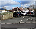
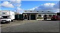
Access road to Halfway Motor Spares scrapyard in Johnston
From the east side of the A4076 Vine Road, opposite the Vine Inn. http://www.geograph.org.uk/photo/4832173
Image: © Jaggery
Taken: 18 Feb 2016
0.04 miles
3
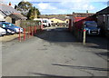
Celtic Flowers shop and van, Johnston
Set back from the east side of the A4076 Vine Road, viewed from the corner of Kiln Road.
Image: © Jaggery
Taken: 18 Feb 2016
0.05 miles
4
Bridleway sign on a Johnston corner
At the edge of the A4076 Vine Road, a green and white bridleway sign points right along Kiln Road.
Image: © Jaggery
Taken: 18 Feb 2016
0.06 miles
5
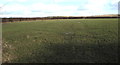
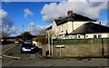
Field on the east side of the A4076 north of Johnston
Rural southwest Pembrokeshire viewed in mid February 2016.
Image: © Jaggery
Taken: 18 Feb 2016
0.06 miles
6
Bus shelter on the A4076 road
A bus shelter on the A4076 road at Johnston.
Image: © Martyn Harries
Taken: 4 Mar 2011
0.06 miles
7
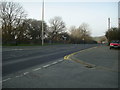
End of the 30 zone in Johnston
At the northern edge of the village, the speed limit on the A4076 Vine Road increases to 50mph.
Image: © Jaggery
Taken: 18 Feb 2016
0.07 miles
8
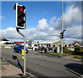
Pelican crossing in the north of Johnston
Across the A4076 Vine Road.
Chambers Dictionary states that "pelican" is adapted from "pedestrian light controlled crossing".
Image: © Jaggery
Taken: 18 Feb 2016
0.07 miles
9
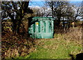
Brickhurst Park electricity substation, Johnston
The Western Power Distribution electricity substation is set back from the corner of Brickhurst Park and the A4076 Vine Road in the north of the village. Its identifier is BRICKHURST PARK JOHNSTON S/S 603765.
Image: © Jaggery
Taken: 18 Feb 2016
0.07 miles
10
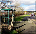
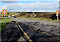
Bus stop and shelter at the northern edge of Johnston
On the west side of the A4076 Vine Road, for buses towards Haverfordwest.
At the far end of the bus stop, the 30mph speed limit in Johnston increases to 50mph.
Image: © Jaggery
Taken: 18 Feb 2016
0.07 miles