IMAGES TAKEN NEAR TO
Redstock Lane, HAVERFORDWEST, SA62 3NQ
Introduction
This page details the photographs taken nearby to Redstock Lane, SA62 3NQ by members of the Geograph project.
The Geograph project started in 2005 with the aim of publishing, organising and preserving representative images for every square kilometre of Great Britain, Ireland and the Isle of Man.

There are currently over 7.5m images from over14,400 individuals and you can help contribute to the project by visiting https://www.geograph.org.uk
Image Map
Images are licensed for reuse under creativecommons.org/licenses/by-sa/2.0
Notes
- Clicking on the map will re-center to the selected point.
- The higher the marker number, the further away the image location is from the centre of the postcode.
Image Listing (7 Images Found)
Images are licensed for reuse under creativecommons.org/licenses/by-sa/2.0
Image
Details
Distance
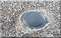
1
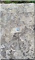
Ordnance Survey Rivet
This OS rivet (damaged) can be found on the NW parapet of Redstock Bridge. It marks a point 37.764m above mean sea level.
Image: © Adrian Dust
Taken: 16 Apr 2017
0.04 miles
2

Lay-by on theA4076
Secluded lay-by on the A4076 from Haverfordwest to Milford Haven, just before Steynton.
Image: © Shaun Butler
Taken: 24 Jun 2008
0.04 miles
3
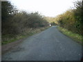
Road at Redstock
A section of the short stretch of road linking the A4076 at Redstock, between Johnston and Steynton.
Image: © Martyn Harries
Taken: 4 Mar 2011
0.05 miles
4

Redstock Lane Near Steynton
Off the Johnston to Steynton road
Image: © Deborah Tilley
Taken: 22 Jan 2016
0.05 miles
5
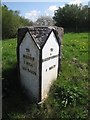
Old Milestone by the A4076, Redstock Bridge
Pembroke double plate by the A4076, in parish of Tiers Cross (Pembrokeshire District), Redstock Bridge, North of Milford Haven.
Inscription reads:-
: TO / MILFORD / 1 MILE / 1515 YARDS : : TO / HAVERFORDWEST / 4 MILES :
Grade II listed by Cadw.
Reference Number: 82696 https://cadwpublic-api.azurewebsites.net/reports/listedbuilding/FullReport?lang=&id=82696
Surveyed
Milestone Society National ID: PEM_HWMF04
Image: © Milestone Society
Taken: Unknown
0.06 miles
6
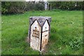
Milestone - Milford 1
There is an OSBM Bolt on the top of the milestone. http://www.geograph.org.uk/photo/5352804
Image: © Adrian Dust
Taken: 16 Apr 2017
0.06 miles
7
Ordnance Survey OSBM Bolt
This OSBM Bolt can be found on the milestone. It marks a point 47.208m above mean sea level. http://www.geograph.org.uk/photo/5352801
Image: © Adrian Dust
Taken: 16 Apr 2017
0.06 miles