IMAGES TAKEN NEAR TO
Victoria Gardens, HAVERFORDWEST, SA62 3NF
Introduction
This page details the photographs taken nearby to Victoria Gardens, SA62 3NF by members of the Geograph project.
The Geograph project started in 2005 with the aim of publishing, organising and preserving representative images for every square kilometre of Great Britain, Ireland and the Isle of Man.

There are currently over 7.5m images from over14,400 individuals and you can help contribute to the project by visiting https://www.geograph.org.uk
Image Map
Images are licensed for reuse under creativecommons.org/licenses/by-sa/2.0
Notes
- Clicking on the map will re-center to the selected point.
- The higher the marker number, the further away the image location is from the centre of the postcode.
Image Listing (76 Images Found)
Images are licensed for reuse under creativecommons.org/licenses/by-sa/2.0
Image
Details
Distance
1
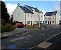
Houses on the north side of Victoria Gardens, Johnston
Modern houses in Victoria Gardens, a cul-de-sac on the east side of the A4076 Vine Road.
Image: © Jaggery
Taken: 18 Feb 2016
0.00 miles
2
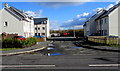
Fence at the eastern end of Victoria Gardens, Johnston
The fence at the eastern end of the cul-de-sac is 50 metres from the A4076 Vine Road.
Image: © Jaggery
Taken: 18 Feb 2016
0.01 miles
3
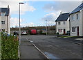
Victoria Gardens, Johnston
Modern houses in a cul-de-sac on the east side of the A4076 Vine Road.
Image: © Jaggery
Taken: 18 Feb 2016
0.01 miles
5
Wash'n Drive, Johnston
Car wash at the back of this http://www.geograph.org.uk/photo/4854523 filling station on the east side of the A4076 Vine Road.
Image: © Jaggery
Taken: 18 Feb 2016
0.03 miles
6
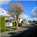
Brookside Avenue, Johnston
On the east side of the A4076 Vine Road.
Image: © Jaggery
Taken: 18 Feb 2016
0.04 miles
7
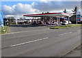
Esso filling station, Johnston
Viewed across the A4076 Vine Road.
Image: © Jaggery
Taken: 18 Feb 2016
0.04 miles
8
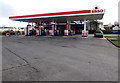
Esso filling station fuel pumps, Johnston
The north side of this http://www.geograph.org.uk/photo/4854523 filling station.
Image: © Jaggery
Taken: 18 Feb 2016
0.04 miles
9
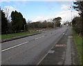
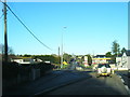
Vine Road, Johnston
Vine Road is part of the A4076, the main road through the village.
The A4076 is St Peter's Road in the middle of Johnston and Milford Road in the south of the village.
Image: © Jaggery
Taken: 18 Feb 2016
0.04 miles
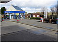
10
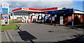
Esso filling station and Shop'n Drive, Johnston
On the east side of the A4076 Vine Road, viewed in February 2016.
An October 2011 Google Earth Street View shows a Shell filling station and Mace shop here.
Image: © Jaggery
Taken: 18 Feb 2016
0.05 miles