IMAGES TAKEN NEAR TO
Broad Haven, HAVERFORDWEST, SA62 3LY
Introduction
This page details the photographs taken nearby to SA62 3LY by members of the Geograph project.
The Geograph project started in 2005 with the aim of publishing, organising and preserving representative images for every square kilometre of Great Britain, Ireland and the Isle of Man.

There are currently over 7.5m images from over14,400 individuals and you can help contribute to the project by visiting https://www.geograph.org.uk
Image Map (Loading...)


Getting Data...Please wait
Leaflet Map data © OpenStreetMap
Images are licensed for reuse under creativecommons.org/licenses/by-sa/2.0
Notes
- Clicking on the map will re-center to the selected point.
- The higher the marker number, the further away the image location is from the centre of the postcode.
Image Listing (4 Images Found)
Images are licensed for reuse under creativecommons.org/licenses/by-sa/2.0
Image
Details
Distance
1
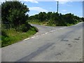
Lane to Broad Haven
A road junction on an otherwise featureless lane crossing this grid square!
Image: © Shaun Butler
Taken: 7 Jul 2008
0.07 miles
2
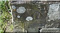
Ordnance Survey Cut Mark
This OS cut mark can be found on the wall post at the entrance to Castle High. It marks a point 106.159m above mean sea level.
Image: © Adrian Dust
Taken: 23 Apr 2017
0.09 miles
3
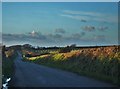
Lane From Rosehill To Haroldston West
The lane ahead forks between Haroldston Hall and Haroldston Tongues.
Image: © Deborah Tilley
Taken: 15 Jan 2016
0.18 miles
4
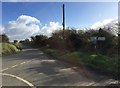
Road junction
The road to Haverfordwest, from Nolton (left) and Broad Haven (behind, right).
Image: © Alan Hughes
Taken: 1 Feb 2018
0.22 miles