IMAGES TAKEN NEAR TO
Rosehill Court, HAVERFORDWEST, SA62 3GB
Introduction
This page details the photographs taken nearby to Rosehill Court, SA62 3GB by members of the Geograph project.
The Geograph project started in 2005 with the aim of publishing, organising and preserving representative images for every square kilometre of Great Britain, Ireland and the Isle of Man.

There are currently over 7.5m images from over14,400 individuals and you can help contribute to the project by visiting https://www.geograph.org.uk
Image Map
Images are licensed for reuse under creativecommons.org/licenses/by-sa/2.0
Notes
- Clicking on the map will re-center to the selected point.
- The higher the marker number, the further away the image location is from the centre of the postcode.
Image Listing (9 Images Found)
Images are licensed for reuse under creativecommons.org/licenses/by-sa/2.0
Image
Details
Distance
1
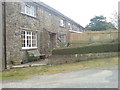
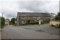
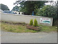
Fir Tree Cottage
At the entrance to Rosehill Holiday Park
Image: © Deborah Tilley
Taken: 11 Jul 2008
0.01 miles
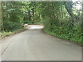
2
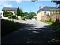
Rosehill hamlet
The hamlet of Rosehill on the back road from the B4341 to Broad Haven.
Image: © Shaun Butler
Taken: 7 Jul 2008
0.02 miles

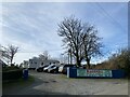
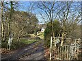
9
Track junction
The track to the right leads to Stember Farm.
Image: © Alan Hughes
Taken: 5 Feb 2023
0.14 miles