IMAGES TAKEN NEAR TO
Sandy Haven, St. Ishmaels, HAVERFORDWEST, SA62 3DN
Introduction
This page details the photographs taken nearby to SA62 3DN by members of the Geograph project.
The Geograph project started in 2005 with the aim of publishing, organising and preserving representative images for every square kilometre of Great Britain, Ireland and the Isle of Man.

There are currently over 7.5m images from over14,400 individuals and you can help contribute to the project by visiting https://www.geograph.org.uk
Image Map (Loading...)


Getting Data...Please wait
Leaflet Map data © OpenStreetMap
Images are licensed for reuse under creativecommons.org/licenses/by-sa/2.0
Notes
- Clicking on the map will re-center to the selected point.
- The higher the marker number, the further away the image location is from the centre of the postcode.
Image Listing (26 Images Found)
Images are licensed for reuse under creativecommons.org/licenses/by-sa/2.0
Image
Details
Distance
1
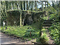
Lime kiln
Lime kiln close to Sandy Haven.
Image: © Alan Hughes
Taken: 19 Apr 2021
0.07 miles
2
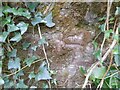
Ordnance Survey Cut Mark
This OS cut mark can be found on the Limekiln south side of the road. It marks a point 18.285m above mean sea level.
Image: © Adrian Dust
Taken: 28 Mar 2022
0.07 miles
3
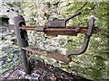
Weighing scales
Double check poise beam scales manufactured by Bartlett’s of Bristol. Presumably used in conjunction with the adjacent lime kiln. See Image
Image: © Alan Hughes
Taken: 19 Apr 2021
0.07 miles
4
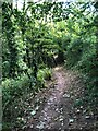
Pembrokeshire Coast Path
Through woodland between Little Castle Head and Sandy Haven
Image: © Eirian Evans
Taken: 30 Aug 2022
0.12 miles
5
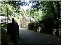
The Anchorage, Sandy Haven
Holiday cottages near Sandyhaven Pill
Image: © Eirian Evans
Taken: 30 Aug 2022
0.13 miles
6
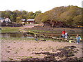
The crab bridge Sandy Haven Pill
This bridge and stepping stones on the coast path have been used by generations of children to collect crabs. The bridge is only above the tide for around 2 hours either side of low tide.
Image: © nantcoly
Taken: 13 May 2006
0.15 miles
7
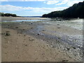
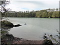
Sandy Haven
A wide expanse of sand at low tide, when it is possible for the Coast Path to cross the river.
Image: © Eirian Evans
Taken: 30 Aug 2022
0.15 miles
8
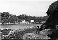
Looking across the pill to Sandy Haven, 1953
From the rocks below the modern caravan park.
Image: © David M Murray-Rust
Taken: 9 Aug 1953
0.16 miles
9
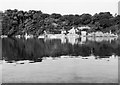
Looking across the pill to Sandy Haven, 1953
Viewed from the end of the lane from Herbrandston at high tide on a windless day.
Image: © David M Murray-Rust
Taken: 13 Aug 1953
0.16 miles