IMAGES TAKEN NEAR TO
Sandy Haven, St. Ishmaels, HAVERFORDWEST, SA62 3DL
Introduction
This page details the photographs taken nearby to SA62 3DL by members of the Geograph project.
The Geograph project started in 2005 with the aim of publishing, organising and preserving representative images for every square kilometre of Great Britain, Ireland and the Isle of Man.

There are currently over 7.5m images from over14,400 individuals and you can help contribute to the project by visiting https://www.geograph.org.uk
Image Map
Images are licensed for reuse under creativecommons.org/licenses/by-sa/2.0
Notes
- Clicking on the map will re-center to the selected point.
- The higher the marker number, the further away the image location is from the centre of the postcode.
Image Listing (10 Images Found)
Images are licensed for reuse under creativecommons.org/licenses/by-sa/2.0
Image
Details
Distance
1
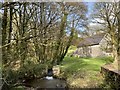
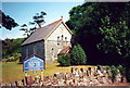
Aenon Baptist Church, Sandy Hill
View along the stream towards the chapel.
Image: © Alan Hughes
Taken: 5 Feb 2020
0.01 miles
2
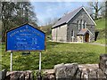
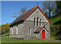
Aenon Baptist Church
Capel Aenon, Sandyhill.
Image: © Alan Hughes
Taken: 19 Apr 2021
0.01 miles
3
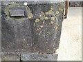
Ordnance Survey Cut Mark
This OS cut mark can be found on the south angle of the Aenon Baptist Chapel. It marks a point 5.582m above mean sea level.
Image: © Adrian Dust
Taken: 28 Mar 2022
0.01 miles
4
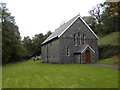
Aenon Baptist Chapel
Tucked away in a small valley just beyond the tidal inlet of Sandyhaven Pill. A datestone in the gable bears the date of 1877.
Image: © Gordon Hatton
Taken: 7 Oct 2016
0.01 miles
5
Capel Aenon Chapel
Capel Aenon,Sunnyhill- addoldy'r Bedyddwyr.
Aenon Baptist Chapel, Sunnyhill.
Image: © Alan Richards
Taken: 3 Jul 1995
0.03 miles
6
Church
Aenon Baptist Church Sandyhill.
Image: © Dara Jasumani
Taken: 27 Apr 2006
0.06 miles
7
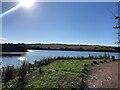
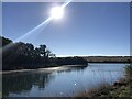
Sandyhaven Pill
The tide is in and the pill is full
Image: © Eirian Evans
Taken: 30 Aug 2022
0.13 miles
9
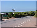
Road junction in Pembrokeshire
The main road shown is the coastal road which has to come inland around the Sandyhaven Pill.
Image: © Jeff Gogarty
Taken: 3 Jun 2016
0.17 miles
10
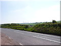
Road to Milford Haven with Oil Refinery
The oil refinery here is near Robeston Cross.
Image: © Jeff Gogarty
Taken: 3 Jun 2016
0.19 miles