IMAGES TAKEN NEAR TO
Marloes, HAVERFORDWEST, SA62 3BQ
Introduction
This page details the photographs taken nearby to SA62 3BQ by members of the Geograph project.
The Geograph project started in 2005 with the aim of publishing, organising and preserving representative images for every square kilometre of Great Britain, Ireland and the Isle of Man.

There are currently over 7.5m images from over14,400 individuals and you can help contribute to the project by visiting https://www.geograph.org.uk
Image Map (46 Images)


Getting Data...Please wait
Leaflet Map data © OpenStreetMap
Images are licensed for reuse under creativecommons.org/licenses/by-sa/2.0
Notes
- Clicking on the map will re-center to the selected point.
- The higher the marker number, the further away the image location is from the centre of the postcode.
Image Listing (46 Images Found)
Images are licensed for reuse under creativecommons.org/licenses/by-sa/2.0
Image
Details
Distance
1
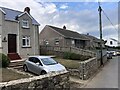
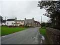
Houses on the main road through Marloes
Image: © Eirian Evans
Taken: 29 Aug 2022
0.01 miles
2
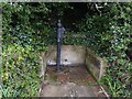
Village pump, Marloes
There is an Ordnance Survey rivet benchmark on the right-hand side wall of this pump. See Image
Image: © Becky Williamson
Taken: 5 Nov 2015
0.02 miles
3
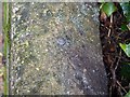
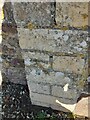
Rivet on pump, Marloes
Ordnance Survey rivet benchmark on wall surrounding village pump. The brass rivet is still clearly visible, but the arrow mark is very faded. For description on database, see http://www.bench-marks.org.uk/bm71477. See also Image
Image: © Becky Williamson
Taken: 5 Nov 2015
0.04 miles
4
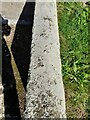
Ordnance Survey Rivet
This OS rivet can be found on the wall of the water pump. It marks a point 53.197m above mean sea level.
Image: © Adrian Dust
Taken: 2 Oct 2022
0.04 miles
5
Marloes
Looking at the village from outside the Moriah Baptist Chapel.
Image: © DS Pugh
Taken: 2 Sep 2009
0.07 miles
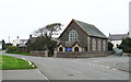
7
Baptist Chapel, Marloes: late August 2019
Image: © Basher Eyre
Taken: 29 Aug 2019
0.08 miles
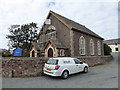
9
Ordnance Survey Cut Mark
This OS cut mark can be found on the gatepost of the chapel. It marks a point 46.940m above mean sea level.
Image: © Adrian Dust
Taken: 2 Oct 2022
0.09 miles
