IMAGES TAKEN NEAR TO
Station Yard, Narberth Road, HAVERFORDWEST, SA61 2XH
Introduction
This page details the photographs taken nearby to Station Yard, Narberth Road, SA61 2XH by members of the Geograph project.
The Geograph project started in 2005 with the aim of publishing, organising and preserving representative images for every square kilometre of Great Britain, Ireland and the Isle of Man.

There are currently over 7.5m images from over14,400 individuals and you can help contribute to the project by visiting https://www.geograph.org.uk
Image Map
Images are licensed for reuse under creativecommons.org/licenses/by-sa/2.0
Notes
- Clicking on the map will re-center to the selected point.
- The higher the marker number, the further away the image location is from the centre of the postcode.
Image Listing (110 Images Found)
Images are licensed for reuse under creativecommons.org/licenses/by-sa/2.0
Image
Details
Distance
1
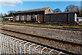
Lineside buildings opposite Haverfordwest railway station
Viewed from the NE end of platform 1.
Image: © Jaggery
Taken: 18 Apr 2014
0.01 miles
2
Yellow railway milepost 276, Haverfordwest
Viewed from the street named Cartlett near the entrance to Haverfordwest railway station. If the milepost dates from the opening of the station in 1854, the distance shown (to London Paddington) is the old route via Gloucester and Bath. The opening of the Severn Tunnel route in 1886 and the Chipping Sodbury & Badminton route in 1903 reduced the distance from 276 miles.
Image: © Jaggery
Taken: 18 Apr 2014
0.02 miles
3
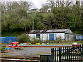
The Brick Yard, Haverfordwest
In May 2018 the name on the single-storey building here https://www.geograph.org.uk/photo/6227402 is THE BRICK YARD.
Image: © Jaggery
Taken: 3 May 2018
0.02 miles
4
Haverfordwest railway station
Looking towards the A40 road bridge.
Image: © John Winterbottom
Taken: 25 Apr 2006
0.02 miles
5
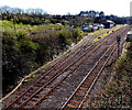
Railway towards Haverfordwest railway station
From the A40 Narberth Road bridge.
Image: © Jaggery
Taken: 18 Apr 2014
0.02 miles
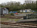
6
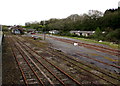
Rusty railway lines, Haverfordwest
Sidings viewed from Haverfordwest station platform 2.
Image: © Jaggery
Taken: 3 May 2018
0.03 miles
7
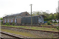
Haverfordwest Goods Shed
It is many years since covered goods sheds were a requirement at railway stations of any importance. Most have long gone, a few have been adopted for new uses and some lie forlorn and forgotten including this one at Haverfordwest. Seemingly not much has changed in the last nine years: Image
Image: © Stephen McKay
Taken: 15 May 2018
0.03 miles
8
Sidings near Haverfordwest railway station
Viewed from Haverfordwest railway station platform 1 in May 2018.
Image: © Jaggery
Taken: 3 May 2018
0.03 miles
9
Cartlett, Haverfordwest
At the end of Cartlett, just past the railway station, is Scotchwell Lodge which houses The Lodge hair and beauty salon. Beyond that is a private road leading to Scotchwell House, birthplace of Admiral John Lort Stokes (1812-85), Australasian explorer and sometime officer of HMS Beagle.
Image: © Stephen McKay
Taken: 15 May 2018
0.03 miles
10
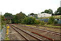
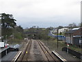
Haverfordwest railway station photo-survey (2)
The view from the station looking in the up (northbound) direction. The bridge carries the A40 trunk road. Note the yellow post giving the mileage from London Paddington.
Haverfordwest station is on the former Great Western Railway (GWR) line from Swansea. The route divides at Clarbeston Road Junction (see [http://www.geograph.org.uk/photo/1524533] ); one branch serves Haverfordwest and Milford Haven, the other serves the ferry terminal at Fishguard.
Haverfordwest station is managed by Arriva Trains Wales who operate most of the passenger services. Arriva runs an hourly service from Manchester Piccadilly as far Carmarthen: this service is extended to Haverfordwest and Milford Haven every two hours.
Image: © Andy F
Taken: 22 Sep 2009
0.03 miles