IMAGES TAKEN NEAR TO
Harrier Road, HAVERFORDWEST, SA61 2TU
Introduction
This page details the photographs taken nearby to Harrier Road, SA61 2TU by members of the Geograph project.
The Geograph project started in 2005 with the aim of publishing, organising and preserving representative images for every square kilometre of Great Britain, Ireland and the Isle of Man.

There are currently over 7.5m images from over14,400 individuals and you can help contribute to the project by visiting https://www.geograph.org.uk
Image Map (Loading...)


Getting Data...Please wait
Leaflet Map data © OpenStreetMap
Images are licensed for reuse under creativecommons.org/licenses/by-sa/2.0
Notes
- Clicking on the map will re-center to the selected point.
- The higher the marker number, the further away the image location is from the centre of the postcode.
Image Listing (5 Images Found)
Images are licensed for reuse under creativecommons.org/licenses/by-sa/2.0
Image
Details
Distance
1
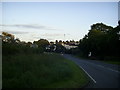
A487 approaching roundabout near Haverfordwest
Looking on the A487 St.Davids Road as it approaches the roundabout that links the bypass into the town centre.
Image: © Martyn Harries
Taken: 28 Aug 2011
0.12 miles
2
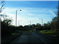
Thomas Parry Way at Dirty Bridge roundabout
Image: © Colin Pyle
Taken: 10 Dec 2012
0.15 miles
3
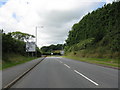
Haverfordwest Northern Bypass
The A487 approaches a final roundabout before heading for St David's.
Image: © Peter Whatley
Taken: 23 Jul 2009
0.15 miles
4
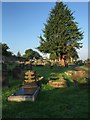
Haverfordwest Cemetery
City Road cemetery in Haverfordwest.
Image: © Alan Hughes
Taken: 14 Sep 2016
0.22 miles
5
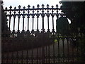
Not so Pearly Gates
Entrance to the cemetery linked to St Martins Church. Next to the City Rd Municipal Cemetery.
Image: © Deborah Tilley
Taken: 18 Jul 2008
0.23 miles