IMAGES TAKEN NEAR TO
Douglas James Way, HAVERFORDWEST, SA61 2TQ
Introduction
This page details the photographs taken nearby to Douglas James Way, SA61 2TQ by members of the Geograph project.
The Geograph project started in 2005 with the aim of publishing, organising and preserving representative images for every square kilometre of Great Britain, Ireland and the Isle of Man.

There are currently over 7.5m images from over14,400 individuals and you can help contribute to the project by visiting https://www.geograph.org.uk
Image Map
Images are licensed for reuse under creativecommons.org/licenses/by-sa/2.0
Notes
- Clicking on the map will re-center to the selected point.
- The higher the marker number, the further away the image location is from the centre of the postcode.
Image Listing (6 Images Found)
Images are licensed for reuse under creativecommons.org/licenses/by-sa/2.0
Image
Details
Distance
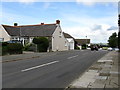
2
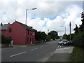
Highgrove, a nursing home
It's had a variety of uses over the years including a hotel and restaurant.
Image: © Deborah Tilley
Taken: 22 Aug 2008
0.08 miles
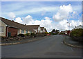
4
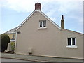
Powder Hall, just off Haven Road
I believe it is so named as there was once an armoury on this site.
4 September 2008
- information from someone with a personal connection :
Powder Hall once held munitions. It is the original building. It has 2 rooms with vaulted ceilings that are currently used as bedrooms.
Image: © Deborah Tilley
Taken: 18 Aug 2008
0.12 miles