IMAGES TAKEN NEAR TO
Finch Close, HAVERFORDWEST, SA61 2RH
Introduction
This page details the photographs taken nearby to Finch Close, SA61 2RH by members of the Geograph project.
The Geograph project started in 2005 with the aim of publishing, organising and preserving representative images for every square kilometre of Great Britain, Ireland and the Isle of Man.

There are currently over 7.5m images from over14,400 individuals and you can help contribute to the project by visiting https://www.geograph.org.uk
Image Map (Loading...)


Getting Data...Please wait
Leaflet Map data © OpenStreetMap
Images are licensed for reuse under creativecommons.org/licenses/by-sa/2.0
Notes
- Clicking on the map will re-center to the selected point.
- The higher the marker number, the further away the image location is from the centre of the postcode.
Image Listing (22 Images Found)
Images are licensed for reuse under creativecommons.org/licenses/by-sa/2.0
Image
Details
Distance
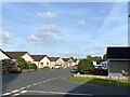
1
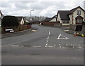
Heritage Gate, Haverfordwest
The northern end of a long cul-de-sac viewed across the B4329 Cardigan Road in the north of Haverfordwest.
Image: © Jaggery
Taken: 11 Mar 2019
0.09 miles
2
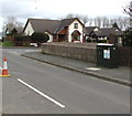
Dark green cabinet alongside Cardigan Road, Haverfordwest
The telecoms cabinet numbered 38 is alongside the B4329 Cardigan Road near the corner of Heritage Gate in March 2019. No cabinet was here in a September 2011 Google Street View.
Image: © Jaggery
Taken: 11 Mar 2019
0.10 miles
3
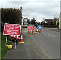
Joining traffic not signal controlled, Cardigan Road, Haverfordwest
One of several Welsh/English temporary signs at road works on March 11th 2019.
Image: © Jaggery
Taken: 11 Mar 2019
0.10 miles
4
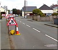
Cardigan Road road works, Haverfordwest
Viewed on March 11th 2019.
Image: © Jaggery
Taken: 11 Mar 2019
0.11 miles
6
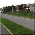
Start of the 30 zone on Cardigan Road, Haverfordwest
Southwest of the A40 junction, the 40mph speed limit on the B4329 Cardigan Road drops to 30mph.
A Welcome to Haverfordwest sign https://www.geograph.org.uk/photo/6085910 is nearby, out of shot on the left.
Image: © Jaggery
Taken: 11 Mar 2019
0.11 miles
7
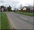
From 30 to 40 on Cardigan Road, Haverfordwest
The speed limit on the B4329 Cardigan Road increases on the approach to the A40 junction.
Viewed in March 2019. A July 2016 Google Street view shows National Speed Limit signs here.
The grey back of a Welcome to Haverfordwest sign https://www.geograph.org.uk/photo/6085910 is on the right.
Image: © Jaggery
Taken: 11 Mar 2019
0.11 miles
8
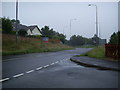
Approaching the B4329/A40 roundabout
Approaching the roundabout where the B4329 meets the A40 Haverfordwest bypass.
Image: © Martyn Harries
Taken: 24 Jul 2010
0.12 miles
9
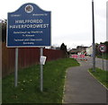
Welcome to Haverfordwest
Located alongside the B4329 Cardigan Road near the A40 junction, the Welsh/English sign shows that Haverfordwest is Hwlffordd in Welsh. The town is twinned with Oberkirch in Germany.
Image: © Jaggery
Taken: 11 Mar 2019
0.12 miles
10
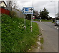
Withybush hospital and airport direction sign, Haverfordwest
Alongside the B4329 Cardigan Road on the approach to the A40 junction.
Image: © Jaggery
Taken: 11 Mar 2019
0.12 miles