IMAGES TAKEN NEAR TO
Park Road, HAVERFORDWEST, SA61 2PD
Introduction
This page details the photographs taken nearby to Park Road, SA61 2PD by members of the Geograph project.
The Geograph project started in 2005 with the aim of publishing, organising and preserving representative images for every square kilometre of Great Britain, Ireland and the Isle of Man.

There are currently over 7.5m images from over14,400 individuals and you can help contribute to the project by visiting https://www.geograph.org.uk
Image Map
Images are licensed for reuse under creativecommons.org/licenses/by-sa/2.0
Notes
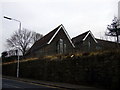
- Clicking on the map will re-center to the selected point.
- The higher the marker number, the further away the image location is from the centre of the postcode.
Image Listing (436 Images Found)
Images are licensed for reuse under creativecommons.org/licenses/by-sa/2.0
Image
Details
Distance
1
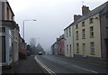
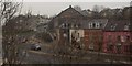
Prendergast on a misty day
Prendergast is the northeastern part of Haverfordwest and lies on the opposite bank of the river from the town itself; it's also the name of the suburb's main street, pictured here looking south. Traditionally it was the area where the Welsh congregated since at one time they were not allowed within the walls of the town after nightfall.
Image: © Natasha Ceridwen de Chroustchoff
Taken: 22 Dec 2006
0.02 miles
2
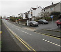
North along Park Road, Haverfordwest
This part of Park Road is between Cherry Grove and Queensway.
Image: © Jaggery
Taken: 20 Feb 2019
0.02 miles
3
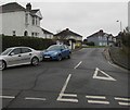
Queensway, Haverfordwest
Queensway ascends from the east side of Park Road.
Image: © Jaggery
Taken: 20 Feb 2019
0.02 miles
4
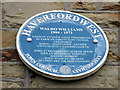
Waldo Williams plaque at Prendergast School
The poet and Welsh Nationalist was born at Prendergast School House on September 30th 1904.
NB The former school to which this plaque was attached had been demolished. The plaque has been relocated nearby.
Image: © Natasha Ceridwen de Chroustchoff
Taken: 27 Jan 2010
0.03 miles
5
Former Prendergast School
The old infant and junior school at Prendergast, replaced in 2008 by a modern version.
Image: © Natasha Ceridwen de Chroustchoff
Taken: 27 Jan 2010
0.03 miles
6
Hill Park Baptist Chapel, Haverfordwest
Situated at the bottom of Prendergast Hill. The black building to the right is a guitar/ music shop.The white building next to it has had an industrial past.In the 1980's it was used for stripping wood in large quantities. However it is very old. The exterior belies this. Inside there is a massive Flemish Chimney from ground floor to roof height situated at the rear inside what is now the kitchen. The left side of the house is considerably older than the right side. This is evident from the building style inside. It is thought that there was once a gap where the right side of the building was until it was extended. The Bridgend Inn is the pink building on the right.
Image: © Deborah Tilley
Taken: 24 Dec 2006
0.03 miles
7
Hill Park Baptist chapel
At the foot of Prendergast Hill. The cream-coloured building, now the vestry, was the original chapel erected in 1858 to serve the Welsh speaking community of Prendergast. In 1888 the larger replacement, side on to the road was built, possibly to house a larger congregation following the end of monolingual services in 1880.
The chapel stands on one of the busy roundabouts of Haverfordwest's deplorable road system.
Image: © Natasha Ceridwen de Chroustchoff
Taken: 21 Jul 2007
0.03 miles
8
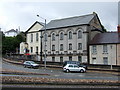
Haverfordwest Register Office
Viewed across Cherry Grove from Park Road. This building is the location of Pembrokeshire Registration Service which is responsible for the registration of all births, deaths, marriages and civil partnerships which occur in Pembrokeshire.
Image: © Jaggery
Taken: 20 Feb 2019
0.03 miles
9

Rear of Hill Park Baptist Chapel, Prendergast, Haverfordwest
The back of this https://www.geograph.org.uk/photo/5762690 chapel viewed from Park Road.
Image: © Jaggery
Taken: 20 Feb 2019
0.04 miles
10
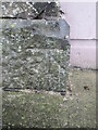
Ordnance Survey Cut Mark
This OS cut mark can be found on the wall of the Prendergast Chapel. It marks a point 7.749m above mean sea level.
Image: © Adrian Dust
Taken: 22 Aug 2015
0.04 miles