IMAGES TAKEN NEAR TO
Queensway, HAVERFORDWEST, SA61 2NU
Introduction
This page details the photographs taken nearby to Queensway, SA61 2NU by members of the Geograph project.
The Geograph project started in 2005 with the aim of publishing, organising and preserving representative images for every square kilometre of Great Britain, Ireland and the Isle of Man.

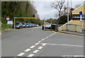
There are currently over 7.5m images from over14,400 individuals and you can help contribute to the project by visiting https://www.geograph.org.uk
Image Map
Images are licensed for reuse under creativecommons.org/licenses/by-sa/2.0
Notes
- Clicking on the map will re-center to the selected point.
- The higher the marker number, the further away the image location is from the centre of the postcode.
Image Listing (356 Images Found)
Images are licensed for reuse under creativecommons.org/licenses/by-sa/2.0
Image
Details
Distance
1
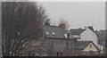
Prospect Place, Haverfordwest
The small bungalow was demolished in 2007.
Image: © Deborah Tilley
Taken: 24 Dec 2006
0.10 miles
2
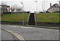
Steps up from Park Road, Haverfordwest
Ascending to Cherry Grove and The Rise.
Image: © Jaggery
Taken: 20 Feb 2019
0.10 miles
3
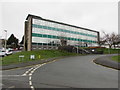
Haverfordwest Register Office
Viewed across Cherry Grove from Park Road. This building is the location of Pembrokeshire Registration Service which is responsible for the registration of all births, deaths, marriages and civil partnerships which occur in Pembrokeshire.
Image: © Jaggery
Taken: 20 Feb 2019
0.10 miles
4
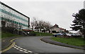
Cherry Grove, Haverfordwest
Cherry Grove ascends from Park Road past the Register Office. https://www.geograph.org.uk/photo/6066101
Image: © Jaggery
Taken: 20 Feb 2019
0.10 miles
5
Scotchwell Car Park entrance from Mill Road, Haverfordwest
The metal frame enforces a 6' 6" vehicle height limit.
Image: © Jaggery
Taken: 3 May 2018
0.10 miles
6
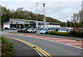
Aldi Haverfordwest
Supermarket viewed across Mill Road.
Image: © Jaggery
Taken: 3 May 2018
0.10 miles
7
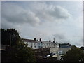
Mill Bank
Overlooking Salutation Square.
Image: © Deborah Tilley
Taken: 10 Sep 2008
0.10 miles
8
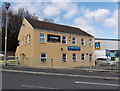
St John Ambulance HQ in Haverfordwest
Pembrokeshire headquarters of St John Ambulance Wales, located next door to Aldi. http://www.geograph.org.uk/photo/3944914
Image: © Jaggery
Taken: 18 Apr 2014
0.11 miles
9
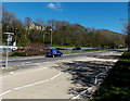
NE along the A40 in Haverfordwest
Viewed from the corner of the street named Cartlett looking northeastwards along the A40.
Image: © Jaggery
Taken: 18 Apr 2014
0.11 miles
10
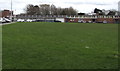
Northwest side of Haverfordwest High VC School
The VC in the school name indicates a Voluntary Controlled School. Such schools must provide for all pupils to take part in a daily act of collective worship, which must reflect the broad traditions of Christian belief and be wholly Christian in character.
Image: © Jaggery
Taken: 11 Mar 2019
0.11 miles