IMAGES TAKEN NEAR TO
Holloway, HAVERFORDWEST, SA61 2JL
Introduction
This page details the photographs taken nearby to Holloway, SA61 2JL by members of the Geograph project.
The Geograph project started in 2005 with the aim of publishing, organising and preserving representative images for every square kilometre of Great Britain, Ireland and the Isle of Man.

There are currently over 7.5m images from over14,400 individuals and you can help contribute to the project by visiting https://www.geograph.org.uk
Image Map
Images are licensed for reuse under creativecommons.org/licenses/by-sa/2.0
Notes
- Clicking on the map will re-center to the selected point.
- The higher the marker number, the further away the image location is from the centre of the postcode.
Image Listing (778 Images Found)
Images are licensed for reuse under creativecommons.org/licenses/by-sa/2.0
Image
Details
Distance
1
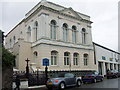
Ebenezer
Calvinistic Methodist chapel in Perrot's Road close to Swan Square and the old bridge. This classical front section, built 1886, is the schoolroom, the older chapel (1817, 1844) lies behind. All three dates are inscribed below the parapet.
Image: © Natasha Ceridwen de Chroustchoff
Taken: 21 Jul 2007
0.01 miles
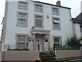
2
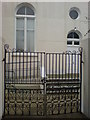
Cleddau Lodge
A fine old house in an elevated position off Kiln Road.
Image: © Deborah Tilley
Taken: 25 Jul 2008
0.01 miles
3
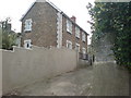
Side entrance to Ebenezer
From Holloway.
Image: © Deborah Tilley
Taken: 30 Jul 2008
0.02 miles
4
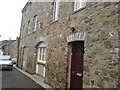
Next to Holloway House
It looks as though it was originally some sort of warehouse.
Image: © Deborah Tilley
Taken: 30 Jul 2008
0.02 miles
5
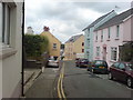
Kiln Road
As seen from the junction with Holloway.
Image: © Deborah Tilley
Taken: 28 Oct 2009
0.02 miles
7
Ebenezer
The upper half of the chapel can just be seen. Castle High modern housing is behind to the right and City Road can be seen snaking up the hill to the left. The grey flat roofed building houses Poundstretcher but stands on the site of the Swan Hotel, a beautiful old coaching house which was pulled down and replaced by another modern monstrosity. The only remains are in the name - Swan Square.
Image: © Deborah Tilley
Taken: 16 Jul 2008
0.02 miles
8
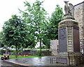
Great War memorial
This striking memorial once stood in the middle of Salutation Square until the square was mostly swallowed up by huge roundabout in the 1960s. The pedestal, which is surmounted by a dragon, lists every man killed, by regiment, along with the names of the major WW1 battles and a fulsome tribute. The memorial gates (left) erected in honour of the WW2 fallen are much less impressive.
Between the two is a plaque to the memory of Pte. Thomas Collins of Camrose who was the only Pembrokeshire man to die at the battle of Rorke's Drift, South Africa, in 1879 - see https://en.wikipedia.org/wiki/Private_Thomas_Collins
Image: © Natasha Ceridwen de Chroustchoff
Taken: 21 Jul 2007
0.02 miles
9
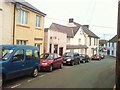
Looking to North Street and the junction with Holloway
The mustard coloured building centre right looks like an old warehouse. It was a carpet showroom until a few years ago.
Image: © Deborah Tilley
Taken: 25 Jul 2008
0.03 miles
10
North Street
In the 1980's Corby Tyres was run from where Bright Lights is now situated.
Taylor Tiles used to be in the blue building on the right.
Image: © Deborah Tilley
Taken: 2 Mar 2009
0.03 miles