IMAGES TAKEN NEAR TO
North Street, HAVERFORDWEST, SA61 2JE
Introduction
This page details the photographs taken nearby to North Street, SA61 2JE by members of the Geograph project.
The Geograph project started in 2005 with the aim of publishing, organising and preserving representative images for every square kilometre of Great Britain, Ireland and the Isle of Man.

There are currently over 7.5m images from over14,400 individuals and you can help contribute to the project by visiting https://www.geograph.org.uk
Image Map
Images are licensed for reuse under creativecommons.org/licenses/by-sa/2.0
Notes
- Clicking on the map will re-center to the selected point.
- The higher the marker number, the further away the image location is from the centre of the postcode.
Image Listing (727 Images Found)
Images are licensed for reuse under creativecommons.org/licenses/by-sa/2.0
Image
Details
Distance
1
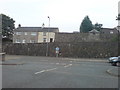
Pyx Parade
Cute name! Situated on the old castle boundary.
Image: © Deborah Tilley
Taken: 17 Jul 2008
0.02 miles
2
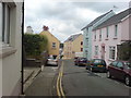
Looking to North Street and the junction with Holloway
The mustard coloured building centre right looks like an old warehouse. It was a carpet showroom until a few years ago.
Image: © Deborah Tilley
Taken: 25 Jul 2008
0.03 miles
3
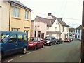
North Street
In the 1980's Corby Tyres was run from where Bright Lights is now situated.
Taylor Tiles used to be in the blue building on the right.
Image: © Deborah Tilley
Taken: 2 Mar 2009
0.03 miles
4
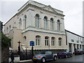
Ebenezer
Calvinistic Methodist chapel in Perrot's Road close to Swan Square and the old bridge. This classical front section, built 1886, is the schoolroom, the older chapel (1817, 1844) lies behind. All three dates are inscribed below the parapet.
Image: © Natasha Ceridwen de Chroustchoff
Taken: 21 Jul 2007
0.03 miles
5
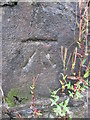
Ordnance Survey Cut Mark
This OS cut mark can be found on the wall to the east of Perrot's Road. It marks a point 14.290m above mean sea level.
Image: © Adrian Dust
Taken: 22 Aug 2015
0.03 miles
6
Cleddau Lodge
A fine old house in an elevated position off Kiln Road.
Image: © Deborah Tilley
Taken: 25 Jul 2008
0.03 miles
7
The old Salvation Army Citadel
Situated on the corner of Holloway and North Street. It featured on an old 1888 map. In later years it became a carpet shop. It features on the Royal Commission on the ancient and historical monuments of Wales website http://www.coflein.gov.uk/en/site/11041/details/SALVATION+ARMY+CITADEL%2C+NORTH+STREET+AND+HOLLOWAY%2C+HAVERFORDWEST/ .
Image: © Deborah Tilley
Taken: 30 Jul 2008
0.04 miles
8
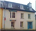
Rock House, North Street
A substantial mid terraced house in the oldest part of town. Looking down the junction to Holloway.
Image: © Deborah Tilley
Taken: 28 Oct 2009
0.04 miles
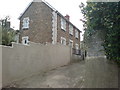
9
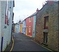
Kiln Road
As seen from the junction with Holloway.
Image: © Deborah Tilley
Taken: 28 Oct 2009
0.04 miles
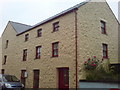
10
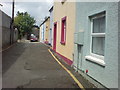
Kiln Road
A short little road leading from Holloway to North Street. The houses have retained a lot of their original character. Just ahead out of sight is the former Taylor Tiles buildings and flats above.
Image: © Deborah Tilley
Taken: 25 Jul 2008
0.05 miles