IMAGES TAKEN NEAR TO
Redhill Park, HAVERFORDWEST, SA61 2HA
Introduction
This page details the photographs taken nearby to Redhill Park, SA61 2HA by members of the Geograph project.
The Geograph project started in 2005 with the aim of publishing, organising and preserving representative images for every square kilometre of Great Britain, Ireland and the Isle of Man.

There are currently over 7.5m images from over14,400 individuals and you can help contribute to the project by visiting https://www.geograph.org.uk
Image Map (Loading...)


Getting Data...Please wait
Leaflet Map data © OpenStreetMap
Images are licensed for reuse under creativecommons.org/licenses/by-sa/2.0
Notes
- Clicking on the map will re-center to the selected point.
- The higher the marker number, the further away the image location is from the centre of the postcode.
Image Listing (5 Images Found)
Images are licensed for reuse under creativecommons.org/licenses/by-sa/2.0
Image
Details
Distance
1
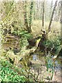
A natural bridge
An ideal crossing for the children of Crow Hill. It spans one of the river Clddau's side streams.
Image: © Deborah Tilley
Taken: 16 Mar 2009
0.17 miles
2
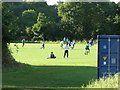
Lower Pitch, New Bridge Meadow, Haverfordwest
The game is between Haverfordwest County (Pembrokeshire League) in blue versus Solva in green. The match was won by the home side, three goals to one.
Image: © nick macneill
Taken: 7 Sep 2010
0.20 miles
4
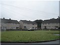
Housing estate on the edge of Haverfordwest
Image: © Simon Mortimer
Taken: 3 Aug 2007
0.21 miles
5
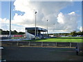
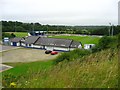
Bridgeview Stadium, Haverfordwest
The home of Haverfordwest County FC who play in the Welsh Prenier League.
Image: © nick macneill
Taken: 7 Sep 2010
0.25 miles