IMAGES TAKEN NEAR TO
St. Marys Street, HAVERFORDWEST, SA61 2DR
Introduction
This page details the photographs taken nearby to St. Marys Street, SA61 2DR by members of the Geograph project.
The Geograph project started in 2005 with the aim of publishing, organising and preserving representative images for every square kilometre of Great Britain, Ireland and the Isle of Man.

There are currently over 7.5m images from over14,400 individuals and you can help contribute to the project by visiting https://www.geograph.org.uk
Image Map
Images are licensed for reuse under creativecommons.org/licenses/by-sa/2.0
Notes
- Clicking on the map will re-center to the selected point.
- The higher the marker number, the further away the image location is from the centre of the postcode.
Image Listing (870 Images Found)
Images are licensed for reuse under creativecommons.org/licenses/by-sa/2.0
Image
Details
Distance
1
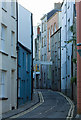
Dark Street, Haverfordwest
I think this captures the essence of this ancient street in the medieval town centre. Just a bit more washing, and it could be Naples.
Image: © Dylan Moore
Taken: 12 Oct 2009
0.00 miles
2

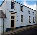
Temperance Hall, St Mary's Street, Haverfordwest
Dated 1888, in Classical style.
Image: © Humphrey Bolton
Taken: 1 Oct 2007
0.00 miles
3

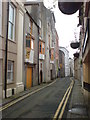
Dark Street, Haverfordwest
Aptly named, rather like the canyon-like streets in, eg, Spanish towns. The building with the broad arch might be the back of the Temperance Hall.
Image: © Humphrey Bolton
Taken: 1 Oct 2007
0.00 miles
4
Dark Street
The recently closed down music business, Swales operated from behind the yellow doors for what seemed like forever.
Image: © Deborah Tilley
Taken: 25 Jul 2008
0.01 miles
6
Former Assembly Rooms, Haverfordwest
The blue plaque http://www.geograph.org.uk/photo/1538993 on the building states that the Assembly Rooms, built in the early 18th century, were the favoured venue of the local gentry for many social events. Leased to St Mary's in 1925, it was used extensively as a church hall and meeting place until the 1950s. By 1970 the building had become unsafe and remained so until conversion to flats in 1997.
Image: © Jaggery
Taken: 18 Apr 2014
0.01 miles
7
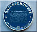
The Assembly Rooms, Haverfordwest
Since "assemblies" were a bête noir of the puritan Daniel Defoe, I thought I'd have a look at what he had to say about the town. But he just says:
"Haverford is a better town than we expected to find, in this remote angle of Britain; 'tis strong, well built, clean and populous". Presumably Haverford had not yet "gone bad" by 1724!
Image: © Dylan Moore
Taken: 12 Oct 2009
0.01 miles
8
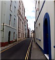
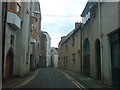
West along Dark Street, Haverfordwest
Viewed from the High Street end looking towards Mariners Square.
Double yellow lines on both sides of the narrow street make parking illegal here at any time.
Image: © Jaggery
Taken: 18 Apr 2014
0.01 miles
9
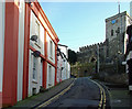
Tower Hill, Haverfordwest
St Mary's Parish Church is at the top.
Image: © Dylan Moore
Taken: 4 Feb 2013
0.01 miles
10
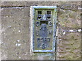
Ordnance Survey Flush Bracket S0587
This can be found on the roadside wall of St Mary's Church.
For more detail see : http://www.bench-marks.org.uk/bm15108
Image: © Peter Wood
Taken: 19 May 2013
0.02 miles