IMAGES TAKEN NEAR TO
Hawthorn Rise, HAVERFORDWEST, SA61 2BQ
Introduction
This page details the photographs taken nearby to Hawthorn Rise, SA61 2BQ by members of the Geograph project.
The Geograph project started in 2005 with the aim of publishing, organising and preserving representative images for every square kilometre of Great Britain, Ireland and the Isle of Man.

There are currently over 7.5m images from over14,400 individuals and you can help contribute to the project by visiting https://www.geograph.org.uk
Image Map (Loading...)


Getting Data...Please wait
Leaflet Map data © OpenStreetMap
Images are licensed for reuse under creativecommons.org/licenses/by-sa/2.0
Notes
- Clicking on the map will re-center to the selected point.
- The higher the marker number, the further away the image location is from the centre of the postcode.
Image Listing (29 Images Found)
Images are licensed for reuse under creativecommons.org/licenses/by-sa/2.0
Image
Details
Distance
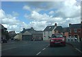
1
City Road ends, Rackhill Terrace begins
The house has been strangely converted into one that has a flat attached, but the roof on the house remains an unaltered pitch whilst the flat has a modern tile. Curious.
Image: © Deborah Tilley
Taken: 8 Aug 2008
0.08 miles
2
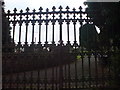
Not so Pearly Gates
Entrance to the cemetery linked to St Martins Church. Next to the City Rd Municipal Cemetery.
Image: © Deborah Tilley
Taken: 18 Jul 2008
0.08 miles
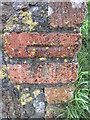
3
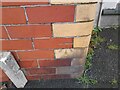
Ordnance Survey Cut Mark
This OS cut mark can be found on No137 City Road. It marks a point 40.443m above mean sea level.
Image: © Adrian Dust
Taken: 13 Apr 2022
0.11 miles
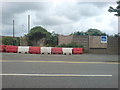
4
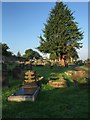
Haverfordwest Cemetery
City Road cemetery in Haverfordwest.
Image: © Alan Hughes
Taken: 14 Sep 2016
0.11 miles
5
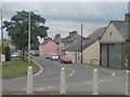
City Road
The junction with Rackhill Terrace is to the right.
Image: © Deborah Tilley
Taken: 19 Jul 2008
0.12 miles
6
City Road, Haverfordwest
The little single storey cottages were once part of Cemetery Row, aptly named as St Martin's Cemetery is nearby. I expect the garage will be developed at some point.
Image: © Deborah Tilley
Taken: 8 Aug 2008
0.13 miles
7
A building plot off St Davids Road
Hard to believe that a house could be built here but it appears that one has stood here before. The ivy conceals the crumbling stone of an old building.
Image: © Deborah Tilley
Taken: 4 Jun 2008
0.14 miles
8
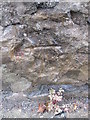
Ordnance Survey Cut Mark
This OS cut mark can be found at the bottom of the steps on Jury Lane. It marks a point 53.969m above mean sea level.
Image: © Adrian Dust
Taken: 22 Aug 2015
0.14 miles
9
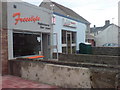
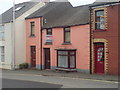
Open for business in City Road
The launderette has been in business for years but the barbers is new. There used to be a butchers here years ago.
Image: © Deborah Tilley
Taken: 8 Aug 2008
0.15 miles
10
Ordnance Survey Cut Mark
This OS cut mark can be found on the wall of No44 Portfield. It marks a point 55.320m above mean sea level.
Image: © Adrian Dust
Taken: 22 Aug 2015
0.16 miles