IMAGES TAKEN NEAR TO
High Street, HAVERFORDWEST, SA61 2BP
Introduction
This page details the photographs taken nearby to High Street, SA61 2BP by members of the Geograph project.
The Geograph project started in 2005 with the aim of publishing, organising and preserving representative images for every square kilometre of Great Britain, Ireland and the Isle of Man.

There are currently over 7.5m images from over14,400 individuals and you can help contribute to the project by visiting https://www.geograph.org.uk
Image Map (Loading...)


Getting Data...Please wait
Leaflet Map data © OpenStreetMap
Images are licensed for reuse under creativecommons.org/licenses/by-sa/2.0
Notes
- Clicking on the map will re-center to the selected point.
- The higher the marker number, the further away the image location is from the centre of the postcode.
Image Listing (968 Images Found)
Images are licensed for reuse under creativecommons.org/licenses/by-sa/2.0
Image
Details
Distance
1
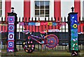
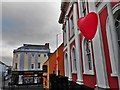
Yarn Bomb Haverfordwest 2015
The whole of the town centre was covered in knitting and crochet; an awesome sight! Shown here is the old Shire Hall gates at the bottom of High Street. It subsequently became the court and then a restaurant but is now sadly unused.
Link to all the photos ..... https://www.facebook.com/media/set/?set=oa.834000243356677&type=1
Image: © Deborah Tilley
Taken: 16 Aug 2015
0.00 miles
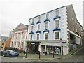
2
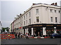
Oxfam Haverfordwest
High Street charity shop on the corner of Hill Lane. There are c700 Oxfam shops in the UK and also Oxfam donation banks in many car parks. Oxfam was founded in Oxford in 1942 as the Oxford Committee for Famine Relief by a group of Quakers, social activists and Oxford academics. It changed its name to Oxfam in 1965.
Image: © Jaggery
Taken: 18 Apr 2014
0.00 miles
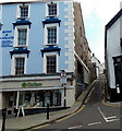
3
Haverfordwest - High Street
Imposing Georgian building on the corner with Hill Lane. The street level shops are a barber and Oxfam.
www.haverfordwestcivicsociety.org.uk
Image: © Colin Smith
Taken: 8 Oct 2021
0.00 miles
4
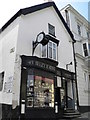
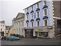
Jewellers in High Street
Bisley H Munt have been established in Haverfordwest since 1796. Sadly the clock outside has lost its fingers.
Image: © Colin Cheesman
Taken: 1 Aug 2009
0.01 miles
5
Cupid Visits Haverfordwest
Outside the old Shire Hall
Image: © Deborah Tilley
Taken: 14 Feb 2015
0.01 miles
6
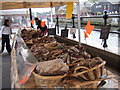
Sausage stall, Haverfordwest French Market
The varieties include ostrich, venison, boar, fig and walnut.
Image: © Natasha Ceridwen de Chroustchoff
Taken: 25 Aug 2006
0.01 miles
7
Victoria Place, Haverfordwest
The extension of High Street towards new Bridge.
Image: © Humphrey Bolton
Taken: 1 Oct 2007
0.01 miles
8
High Street, Haverfordwest
At the bottom end, High Street widens, perhaps a former market area, and there is a row of varied buildings: The Old Three Crowns, the Shire Hall of 1835 (designed by William Owen) and a pair of 19C shops with unusual window heads to the upper floors.
Image: © Humphrey Bolton
Taken: 1 Oct 2007
0.01 miles
9

Haverfordwest: The Friars
Looking up from the High Street at its continuation, The Friars, an attractive street with pastel coloured buildings. We are looking during a short period of time when the frontages on neither side of the street are catching the sun.
Image: © Chris Downer
Taken: 18 Aug 2010
0.01 miles
10
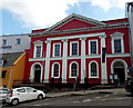
Haverfordwest Shire Hall
Located on the south side of High Street, Grade II* listed in 1951 as one of the most distinguished early 19th century public buildings in the region.
The blue plaque on the wall records that the Shire Hall was built in 1835 to the design of local architect William Owen. It is regarded as one of the town's most impressive buildings. As well as being the chief centre for the administration of justice in the county, it was also the meeting place of the former Pembrokeshire County Council.
Image: © Jaggery
Taken: 18 Apr 2014
0.01 miles