IMAGES TAKEN NEAR TO
Winch Lane, HAVERFORDWEST, SA61 1RR
Introduction
This page details the photographs taken nearby to Winch Lane, SA61 1RR by members of the Geograph project.
The Geograph project started in 2005 with the aim of publishing, organising and preserving representative images for every square kilometre of Great Britain, Ireland and the Isle of Man.

There are currently over 7.5m images from over14,400 individuals and you can help contribute to the project by visiting https://www.geograph.org.uk
Image Map
Images are licensed for reuse under creativecommons.org/licenses/by-sa/2.0
Notes
- Clicking on the map will re-center to the selected point.
- The higher the marker number, the further away the image location is from the centre of the postcode.
Image Listing (243 Images Found)
Images are licensed for reuse under creativecommons.org/licenses/by-sa/2.0
Image
Details
Distance
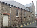
1
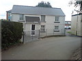
Cottage in Riflemans Lane
Situated next to St Thomas' Surgery.The playing fields are behind, although vastly reduced in size to make way for extra parking due to the loss of spaces on the Green as a result of the new leisure complex.
Image: © Deborah Tilley
Taken: 15 Aug 2008
0.04 miles

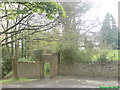
3
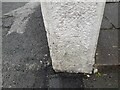
Ordnance Survey Cut Mark
This OS cut mark can be found on the gatepost of Winch House. It marks a point 39.404m above mean sea level.
Image: © Adrian Dust
Taken: 13 Apr 2022
0.04 miles
4
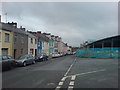
Bush Row
At the junction with St Thomas' Green. The new leisure development is under construction on the right.
Image: © Deborah Tilley
Taken: 30 Jul 2008
0.06 miles
5
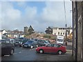
The Old Hospital
Demolition underway for a new leisure centre on St Thomas' Green. Bush Row terraced housing is in the distance with St Thomas Church beyond. The red car is exiting Riflemans Lane where the doctors surgery is situated.
Image: © Deborah Tilley
Taken: 22 Feb 2007
0.08 miles
6
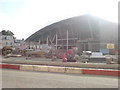
St Thomas' Green. New leisure complex
Due for completion late 2008
Image: © Deborah Tilley
Taken: 22 Sep 2008
0.08 miles
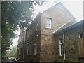
7
The Old Workhouse - now council flats
Taken from the hill to the Parade, the old poorhouse can be seen beyond the lovely stone arch. The occupants in the past might not have appreciated the stonework.
Image: © Deborah Tilley
Taken: 28 Apr 2008
0.09 miles
8
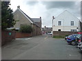
Looking up Riflemans Lane to St Thomas' Green
From outside St Thomas' Surgery.
Image: © Deborah Tilley
Taken: 15 Aug 2008
0.09 miles
9
Front aspect of the old workhouse
There would have been lovely views over the priory ruins and the Cleddau but they are now obscured by overgrown trees. The old workhouse is now owned by the council and has been converted into flats. There is still an air of desperation to the place with boarded up windows,loud music, rubbish everywhere and even a bath dumped outside. Despite all this, some occupants still strive to make it a nice place to live with tubs of bright flowers.
Image: © Deborah Tilley
Taken: 4 Oct 2008
0.10 miles
10
Riflemans Lane
Leading from St Thomas' Green to St Thomas' Surgery.
Image: © Deborah Tilley
Taken: 30 Jul 2008
0.10 miles