IMAGES TAKEN NEAR TO
Hermons Hill, HAVERFORDWEST, SA61 1PT
Introduction
This page details the photographs taken nearby to Hermons Hill, SA61 1PT by members of the Geograph project.
The Geograph project started in 2005 with the aim of publishing, organising and preserving representative images for every square kilometre of Great Britain, Ireland and the Isle of Man.

There are currently over 7.5m images from over14,400 individuals and you can help contribute to the project by visiting https://www.geograph.org.uk
Image Map
Images are licensed for reuse under creativecommons.org/licenses/by-sa/2.0
Notes
- Clicking on the map will re-center to the selected point.
- The higher the marker number, the further away the image location is from the centre of the postcode.
Image Listing (937 Images Found)
Images are licensed for reuse under creativecommons.org/licenses/by-sa/2.0
Image
Details
Distance
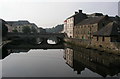
1
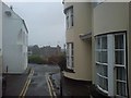
Hermon's Hill: Haverfordwest
The castle is in the distance.
Image: © Dylan Moore
Taken: 24 Apr 2009
0.01 miles
2
Hermon's Hill House (on the right)
An 18th century grade 2 listed residence allegedly designed by Nash. Imposing views over the river. Now a holiday home.
Image: © Deborah Tilley
Taken: 4 Oct 2008
0.01 miles
3
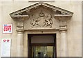
The pediment of the Post Office doorway, Quay Street. Haverfordwest
This post office was built in 1934-6, and although the pediment is somewhat of an anachronism it does protect the beautifully carved royal coat of arms.
Image: © Humphrey Bolton
Taken: 1 Oct 2007
0.03 miles
4
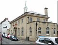
The Post Office, Quay Street, Haverfordwest
This was built of Bath stone in 1934-6. Let's hope that this building remains as a post office; so many are being sold off as sorting offices are moved to industrial estates and post offices into soulless shop units.
Image: © Humphrey Bolton
Taken: 1 Oct 2007
0.03 miles
5
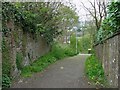
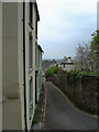
Footpath: Haverfordwest
This leads from St Thomas' church down to Quay Street.
Image: © Dylan Moore
Taken: 24 Apr 2009
0.03 miles
6
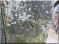
Ordnance Survey Cut Mark
This OS cut mark can be found on the short post at the top of the steps on Hermon's Hill. It marks a point 31.199m above mean sea level.
Image: © Adrian Dust
Taken: 22 Aug 2015
0.03 miles
8
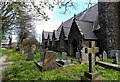
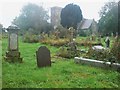
North side of St Thomas a Becket church, Haverfordwest
In the Parish of Haverfordwest, Church in Wales Diocese of St Davids.
The church dates from the 12th century, mostly rebuilt in the 19th century
apart from the medieval tower http://www.geograph.org.uk/photo/4463382 on the right.
Image: © Jaggery
Taken: 18 Apr 2014
0.04 miles
9
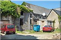
Off Hill Lane
A yard behind Bisley H Munts, jewellers in High Street. Accessed via Hill Lane. A potential development site but currently home to birds.
Image: © Deborah Tilley
Taken: 17 Jun 2006
0.04 miles