IMAGES TAKEN NEAR TO
Hill Lane, HAVERFORDWEST, SA61 1PR
Introduction
This page details the photographs taken nearby to Hill Lane, SA61 1PR by members of the Geograph project.
The Geograph project started in 2005 with the aim of publishing, organising and preserving representative images for every square kilometre of Great Britain, Ireland and the Isle of Man.

There are currently over 7.5m images from over14,400 individuals and you can help contribute to the project by visiting https://www.geograph.org.uk
Image Map (Loading...)


Getting Data...Please wait
Leaflet Map data © OpenStreetMap
Images are licensed for reuse under creativecommons.org/licenses/by-sa/2.0
Notes
- Clicking on the map will re-center to the selected point.
- The higher the marker number, the further away the image location is from the centre of the postcode.
Image Listing (975 Images Found)
Images are licensed for reuse under creativecommons.org/licenses/by-sa/2.0
Image
Details
Distance
1
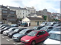
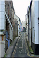
Looking above the cars to the rear of Dark Street
The tower of St Mary's Church seen peeking out in the distance.
Image: © Deborah Tilley
Taken: 12 Jul 2008
0.01 miles
2
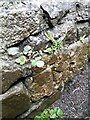
Ordnance Survey Cut Mark
This OS cut mark can be found on the wall west side of Hill Lane. It marks a point 23.521m above mean sea level.
Image: © Adrian Dust
Taken: 13 Apr 2022
0.01 miles
4
Looking down Hill Lane
Haverfordwest castle in the distance.
Image: © Deborah Tilley
Taken: 17 Jun 2006
0.01 miles
5
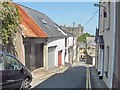
Hill Lane, Haverfordwest
View from the High Street.
Image: © Dylan Moore
Taken: 31 Jan 2011
0.01 miles
6
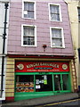
Bright colours and fast food in the High Street
Some of the colour schemes here leave a lot to be desired! The good news is that grant-aided refurbishment is currently (2008) benefiting a number of town centre premises, including several in this historic street.
Image: © Natasha Ceridwen de Chroustchoff
Taken: 18 Nov 2008
0.02 miles
7
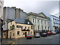
Shire Hall
The old Shire hall in the High Street is an imposing building in classical style (1835, William Owen architect). It is now redundant: its acquistion by pub chain has thankfully been averted but its future is as yet undecided - an arts centre is a possibility.
The Old Three Crowns next door dates from the C18 and has happily had its original name restored after a stint as an Irish pub.
The concrete structure looming above is typical of the careless way in which Haverfordwest's historical heritage was treated in the second half of the C20.
Image: © Natasha Ceridwen de Chroustchoff
Taken: 21 Jul 2007
0.02 miles
8
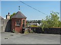
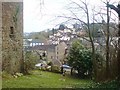
Folly at Hill Lane, Haverfordwest
Situated in the car park of the solicitors offices. Age unknown but there are a number of rotundas shown on an old 1760 map of the town.
Image: © Deborah Tilley
Taken: 17 Jun 2006
0.02 miles
9
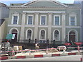
Shire Hall - once the Courthouse, now abandoned
Overseeing road improvements. If only improvements would begin on the Hall itself. Loved by the people but unwanted by the authorities. Who knows what its fate will be.
Image: © Deborah Tilley
Taken: 21 Jul 2008
0.02 miles
10
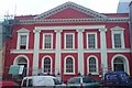
Rebirth of the Shire Hall
In a rather fetching shade of raspberry. The colour has raised a few eyebrows as some years ago a building in Victoria Place was made by the powers that be, to repaint from an attractive shade of deep blue to magnolia, which was deemed more 'in keeping' with a period building...
Image: © Deborah Tilley
Taken: 28 Oct 2009
0.02 miles