IMAGES TAKEN NEAR TO
Beech Tree Gardens, HAVERFORDWEST, SA61 1NE
Introduction
This page details the photographs taken nearby to Beech Tree Gardens, SA61 1NE by members of the Geograph project.
The Geograph project started in 2005 with the aim of publishing, organising and preserving representative images for every square kilometre of Great Britain, Ireland and the Isle of Man.

There are currently over 7.5m images from over14,400 individuals and you can help contribute to the project by visiting https://www.geograph.org.uk
Image Map
Images are licensed for reuse under creativecommons.org/licenses/by-sa/2.0
Notes
- Clicking on the map will re-center to the selected point.
- The higher the marker number, the further away the image location is from the centre of the postcode.
Image Listing (167 Images Found)
Images are licensed for reuse under creativecommons.org/licenses/by-sa/2.0
Image
Details
Distance
1
Grove Place
On the Southern end of St Thomas' Green.
Image: © Deborah Tilley
Taken: 22 Aug 2008
0.03 miles
2
The Oak on St Thomas' Green
Part of Morgans terrace.
Image: © Deborah Tilley
Taken: 22 Aug 2008
0.03 miles
3
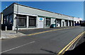
Ellis Avenue, Haverfordwest
Pembrokeshire Care & Mobility Centre is on the left. DSR Batteries and Electrical is on the right.
Image: © Jaggery
Taken: 18 Apr 2014
0.03 miles

5
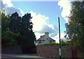
The Grove, on St Thomas' Green
This early 1960's house is soon to be demolished and replaced with bungalows and apartments in its generous grounds.
Image: © Deborah Tilley
Taken: 22 Aug 2008
0.05 miles
6
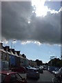
A dramatic sky
On St Thomas' Green looking towards Merlin's Hill.
Image: © Deborah Tilley
Taken: 22 Aug 2008
0.06 miles
7
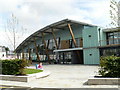
Haverfordwest Leisure Centre
Built at a cost of £8m this new Leisure Centre provides excellent facilities for local residents in an attractive looking building. The Centre also uses biomass boilers.
Image: © Colin Cheesman
Taken: 1 Aug 2009
0.07 miles
8
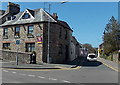
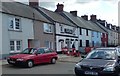
Normandie House, Haverfordwest
Guest house at 1 Merlin's Hill, on the corner of Shipman's Lane (on the right).
Estate agents' AUCTION boards were on the wall in mid April 2014.
Image: © Jaggery
Taken: 18 Apr 2014
0.08 miles
9
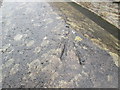
Ordnance Survey Rivet
This OS rivet can be found on the wall at the road junction. It marks a point 46.962m above mean sea level.
Image: © Adrian Dust
Taken: 22 Aug 2015
0.08 miles
10
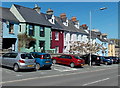
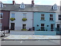
Colourful Merlin's Hill houses in Haverfordwest
Looking towards the Shipman's Lane junction.
Image: © Jaggery
Taken: 18 Apr 2014
0.08 miles