IMAGES TAKEN NEAR TO
Pembroke Road, HAVERFORDWEST, SA61 1LY
Introduction
This page details the photographs taken nearby to Pembroke Road, SA61 1LY by members of the Geograph project.
The Geograph project started in 2005 with the aim of publishing, organising and preserving representative images for every square kilometre of Great Britain, Ireland and the Isle of Man.

There are currently over 7.5m images from over14,400 individuals and you can help contribute to the project by visiting https://www.geograph.org.uk
Image Map (Loading...)


Getting Data...Please wait
Leaflet Map data © OpenStreetMap
Images are licensed for reuse under creativecommons.org/licenses/by-sa/2.0
Notes
- Clicking on the map will re-center to the selected point.
- The higher the marker number, the further away the image location is from the centre of the postcode.
Image Listing (11 Images Found)
Images are licensed for reuse under creativecommons.org/licenses/by-sa/2.0
Image
Details
Distance
1
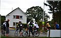
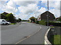
Pembrokeshire Charity Bike Ride 12 August 2012
Leaving the Rugby Club in Merlin's Bridge and entering the Pembroke Road for a 15, 30 or 60 mile ride
Image: © Deborah Tilley
Taken: 12 Aug 2012
0.07 miles
4
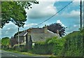
Woodbine Farm, Merlins Bridge
It looks very old but I cannot readily find any history on it
Image: © Deborah Tilley
Taken: 27 Jun 2015
0.11 miles
7
Emmanuel Christian Centre, Haverfordwest
Image: © Peter Whatley
Taken: 23 Jul 2009
0.15 miles