IMAGES TAKEN NEAR TO
Penns Close, HAVERFORDWEST, SA61 1EX
Introduction
This page details the photographs taken nearby to Penns Close, SA61 1EX by members of the Geograph project.
The Geograph project started in 2005 with the aim of publishing, organising and preserving representative images for every square kilometre of Great Britain, Ireland and the Isle of Man.

There are currently over 7.5m images from over14,400 individuals and you can help contribute to the project by visiting https://www.geograph.org.uk
Image Map
Images are licensed for reuse under creativecommons.org/licenses/by-sa/2.0
Notes
- Clicking on the map will re-center to the selected point.
- The higher the marker number, the further away the image location is from the centre of the postcode.
Image Listing (14 Images Found)
Images are licensed for reuse under creativecommons.org/licenses/by-sa/2.0
Image
Details
Distance
2
Redhill Prep School, Haverfordwest
Taken from the racecourse the red roof can just be seen. Based in a quiet area in Scarrowscant Lane.
Image: © Deborah Tilley
Taken: 4 Jun 2008
0.15 miles
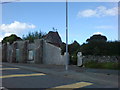
3
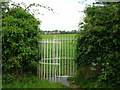
Kissing gate entrance to Haverfordwest Race Course
The entrance to the former racecourse is opposite the junction of Bethany Road and Palmerston Road.
Image: © Simon Mortimer
Taken: 11 Aug 2012
0.15 miles
4
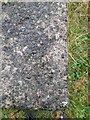
Ordnance Survey Rivet
This OS rivet can be found on the drain cover NW side of the path. It marks a point 42.881m above mean sea level.
Image: © Adrian Dust
Taken: 13 Apr 2022
0.15 miles
5
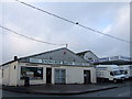
Bakery, Snowdrop Lane, Haverfordwest
Snowdrop Lane is in the outlying Scarrowscant area to the west of the town and contains a range of large commercial premises such as these with plenty of room for storage and parking.
Image: © Natasha Ceridwen de Chroustchoff
Taken: 28 Dec 2006
0.16 miles
6
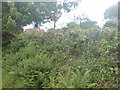
Ruin in Snowdrop Lane
A prime building plot that has been in this state for as long as I can remember.
Image: © Deborah Tilley
Taken: 22 Aug 2008
0.17 miles
7
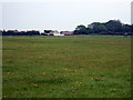
Hwlffordd/Haverfordwest racecourse
A substantial course, bisected by the B4327 Dale road on the western edge of Haverfordwest, but long abandoned for horse-racing. Now given over to recreation, football, and walking - although part of it seems to be slated for 'development'. Modern housing in the Scarrowscant area of the town can be seen along the southeastern perimeter of the course.
Image: © Natasha Ceridwen de Chroustchoff
Taken: 8 Jun 2007
0.18 miles
9
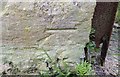
Ordnance Survey Cut Mark
This OS cut mark can be found on the barn at Palmerston Farm. It marks a point 59.946m above mean sea level.
Image: © Adrian Dust
Taken: 16 Apr 2017
0.20 miles
10
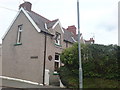
Nelson Villas in Snowdrop Lane
Once surrounded by countryside these cottages now have small businesses for company.
Image: © Deborah Tilley
Taken: 15 Aug 2008
0.20 miles