IMAGES TAKEN NEAR TO
Scarrowscant Lane, HAVERFORDWEST, SA61 1EP
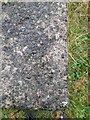
Introduction
This page details the photographs taken nearby to Scarrowscant Lane, SA61 1EP by members of the Geograph project.
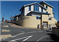
The Geograph project started in 2005 with the aim of publishing, organising and preserving representative images for every square kilometre of Great Britain, Ireland and the Isle of Man.

There are currently over 7.5m images from over14,400 individuals and you can help contribute to the project by visiting https://www.geograph.org.uk
Image Map
Images are licensed for reuse under creativecommons.org/licenses/by-sa/2.0
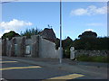
Notes
- Clicking on the map will re-center to the selected point.
- The higher the marker number, the further away the image location is from the centre of the postcode.
Image Listing (22 Images Found)
Images are licensed for reuse under creativecommons.org/licenses/by-sa/2.0
Image
Details
Distance
1
Ruin in Snowdrop Lane
A prime building plot that has been in this state for as long as I can remember.
Image: © Deborah Tilley
Taken: 22 Aug 2008
0.13 miles
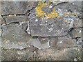
2
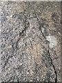
Ordnance Survey Rivet
This OS rivet can be found on the drain cover NW side of the path. It marks a point 42.881m above mean sea level.
Image: © Adrian Dust
Taken: 13 Apr 2022
0.14 miles
3
Ordnance Survey Cut Mark
This OS cut mark can be found on the wall SE side of the Merlins Hill. It marks a point 37.869m above mean sea level.
Image: © Adrian Dust
Taken: 13 Apr 2022
0.14 miles
4
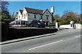
The Glen, Haverfordwest
Pub and restaurant set back from the west side of the A487 Merlin's Hill.
Image: © Jaggery
Taken: 18 Apr 2014
0.14 miles
5
Ordnance Survey Rivet
This OS rivet can be found on the concrete base at the SW angle of No54 Portfield Avenue. It marks a point 57.427m above mean sea level.
Image: © Adrian Dust
Taken: 22 Aug 2015
0.16 miles
6
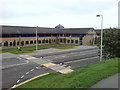
Pembrokeshire College
A well designed modern building with a nice atmosphere.
Image: © Deborah Tilley
Taken: 28 Aug 2008
0.16 miles
7
Coleg Sir Benfro/Pembrokeshire College
Haverfordwest's seat of higher learning.
Image: © Natasha Ceridwen de Chroustchoff
Taken: 4 Aug 2008
0.18 miles
8
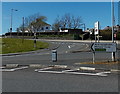
7 miles from Haverfordwest to Milford Haven
The signs points left (SW) down the A487 Merlin's Hill towards the A4076.
Image: © Jaggery
Taken: 18 Apr 2014
0.18 miles
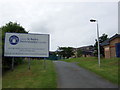
9
Mary Immaculate Catholic School in Haverfordwest
Built in 2007, the Catholic primary school is at the top of Merlin's Hill.
Image: © Jaggery
Taken: 18 Apr 2014
0.18 miles
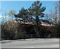
10
Partly hidden Haverfordwest Delivery Office
Vegetation obscures the east (Merlins Hill) side of the Royal Mail premises in Merlins Bridge.
Image: © Jaggery
Taken: 18 Apr 2014
0.19 miles