IMAGES TAKEN NEAR TO
Glenfields Road, HAVERFORDWEST, SA61 1EB
Introduction
This page details the photographs taken nearby to Glenfields Road, SA61 1EB by members of the Geograph project.
The Geograph project started in 2005 with the aim of publishing, organising and preserving representative images for every square kilometre of Great Britain, Ireland and the Isle of Man.

There are currently over 7.5m images from over14,400 individuals and you can help contribute to the project by visiting https://www.geograph.org.uk
Image Map (Loading...)


Getting Data...Please wait
Leaflet Map data © OpenStreetMap
Images are licensed for reuse under creativecommons.org/licenses/by-sa/2.0
Notes
- Clicking on the map will re-center to the selected point.
- The higher the marker number, the further away the image location is from the centre of the postcode.
Image Listing (15 Images Found)
Images are licensed for reuse under creativecommons.org/licenses/by-sa/2.0
Image
Details
Distance
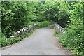
1
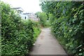
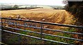
Bridleway, Under the Hills
Here the Brunel Trail is on a bridleway having left the highway at the entrance to the caravan site, top left.
Image: © M J Roscoe
Taken: 23 May 2024
0.13 miles
2
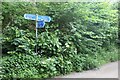
Cycle route signpost on bridleway
Here the Brunel Trail from Haverfordwest rejoins NCR4 to head towards Neyland.
Image: © M J Roscoe
Taken: 23 May 2024
0.13 miles
3
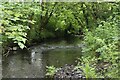
Merlin's Brook below bridleway bridge
Looking downstream from edge of waterway.
Image: © M J Roscoe
Taken: 23 May 2024
0.13 miles
4
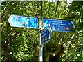
National Cycle Network Route Sign
NCN Route 4 sign, showing the link route into Haverfordwest, the main route west to Broad Haven and south to Neyland.
Image: © shirokazan
Taken: 30 May 2010
0.14 miles
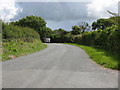
5
Bridleway bridge over Merlin's Brook
Stone bridge on Brunel Trail.
Image: © M J Roscoe
Taken: 23 May 2024
0.14 miles
6
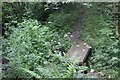
Footbridge over tributary of Merlin's Brook
Public footpath on right bank of Merlin's Brook.
Image: © M J Roscoe
Taken: 23 May 2024
0.14 miles
7
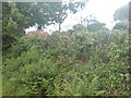
Redhill Prep School, Haverfordwest
Taken from the racecourse the red roof can just be seen. Based in a quiet area in Scarrowscant Lane.
Image: © Deborah Tilley
Taken: 4 Jun 2008
0.14 miles
10
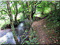
Llwybr Merlin's Brook / Merlin's Brook Path
Llwybr cyhoeddus ar lan Nant Merlin's Brook.
A public footpath running alongside Merlin's Brook.
Image: © Alan Richards
Taken: 7 Sep 2016
0.18 miles