IMAGES TAKEN NEAR TO
Iorwerth Street, SWANSEA, SA5 9NP
Introduction
This page details the photographs taken nearby to Iorwerth Street, SA5 9NP by members of the Geograph project.
The Geograph project started in 2005 with the aim of publishing, organising and preserving representative images for every square kilometre of Great Britain, Ireland and the Isle of Man.

There are currently over 7.5m images from over14,400 individuals and you can help contribute to the project by visiting https://www.geograph.org.uk
Image Map
Images are licensed for reuse under creativecommons.org/licenses/by-sa/2.0
Notes
- Clicking on the map will re-center to the selected point.
- The higher the marker number, the further away the image location is from the centre of the postcode.
Image Listing (51 Images Found)
Images are licensed for reuse under creativecommons.org/licenses/by-sa/2.0
Image
Details
Distance
1
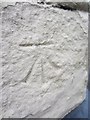
Ordnance Survey Cut Mark
This OS cut mark can be found on No1A Approach Road. It marks a point 56.574m above mean sea level.
Image: © Adrian Dust
Taken: 11 Dec 2013
0.07 miles
2
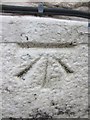
Ordnance Survey Cut Mark
This OS cut mark can be found on No40 Courtney Street. It marks a point 50.682m above mean sea level.
Image: © Adrian Dust
Taken: 11 Dec 2013
0.08 miles
3
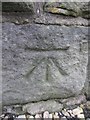
Ordnance Survey Cut Mark
This OS cut mark can be found on the wall of No91 Robert Street. It marks a point 56.126m above mean sea level.
Image: © Adrian Dust
Taken: 11 Dec 2013
0.10 miles
4
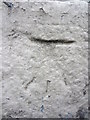
Ordnance Survey Cut Mark
This OS cut mark can be found on No26 Courtney Street. It marks a point 50.643m above mean sea level.
Image: © Adrian Dust
Taken: 11 Dec 2013
0.10 miles
7
Courtney Street, Swansea
Viewed across Llangyfelach Road.
Image: © Jaggery
Taken: 6 Dec 2013
0.13 miles
8
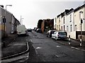
One-way system along Courtney Street, Swansea
Viewed from the corner of Verig Street. http://www.geograph.org.uk/photo/3771865
Image: © Jaggery
Taken: 6 Dec 2013
0.15 miles
9
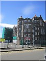
Landore School
The Ordnance Survey used the school vane, now missing, as a 3rd Order Triangulation Point (Intersected Station SN80/INT010).
Image: © Adrian Dust
Taken: 23 Jul 2012
0.15 miles
10
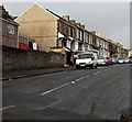
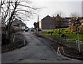
Verig Street, Swansea
Viewed from Courtney Street looking along a 135 metre long row of houses towards Robert Street.
Image: © Jaggery
Taken: 6 Dec 2013
0.17 miles