IMAGES TAKEN NEAR TO
Llangyfelach Road, SWANSEA, SA5 9LE
Introduction
This page details the photographs taken nearby to Llangyfelach Road, SA5 9LE by members of the Geograph project.
The Geograph project started in 2005 with the aim of publishing, organising and preserving representative images for every square kilometre of Great Britain, Ireland and the Isle of Man.

There are currently over 7.5m images from over14,400 individuals and you can help contribute to the project by visiting https://www.geograph.org.uk
Image Map
Images are licensed for reuse under creativecommons.org/licenses/by-sa/2.0
Notes
- Clicking on the map will re-center to the selected point.
- The higher the marker number, the further away the image location is from the centre of the postcode.
Image Listing (73 Images Found)
Images are licensed for reuse under creativecommons.org/licenses/by-sa/2.0
Image
Details
Distance
1
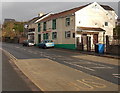
Three Feathers Inn, Swansea
Pub at 189 Llangyfelach Road.
Image: © Jaggery
Taken: 6 Dec 2013
0.02 miles
2
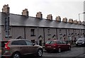
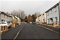
36 chimney pots, Pentre Mawr Road, Swansea
The row of slate-roofed houses is on the south side of Pentre Mawr Road
viewed looking towards the B4489 Llangyfelach Road.
Image: © Jaggery
Taken: 6 Dec 2013
0.02 miles
3
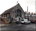
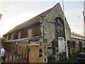
Former Glynn Vivian Miners' Mission, Swansea
Viewed across Pentre Mawr Road. The International Miners' Mission was founded in the first decade of the 20th century by Swansea-born Richard Glynn Vivian, a wealthy mine owner and industrialist.
Image: © Jaggery
Taken: 6 Dec 2013
0.04 miles
4
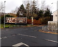
Wide billboard alongside Llangyfelach Road, Swansea
Viewed from Pentre Mawr Road.
Image: © Jaggery
Taken: 6 Dec 2013
0.04 miles
5
Northern end of Mainwaring Terrace, Swansea
Looking north towards a railway underpass. http://www.geograph.org.uk/photo/3770395
Image: © Jaggery
Taken: 6 Dec 2013
0.05 miles
6

Ordnance Survey Cut Mark
This OS cut mark can be found on a pillar of the boundary wall of the old chapel (No53 Pentre Mawr Road). It marks a point 37.183m above mean sea level. http://www.geograph.org.uk/photo/3775982
Image: © Adrian Dust
Taken: 11 Dec 2013
0.05 miles
7
Old Chapel
Chapel at No53 Pentre Mawr Road. There is an OS cut mark on one of the boundary wall pillars. http://www.geograph.org.uk/photo/3775972
Image: © Adrian Dust
Taken: 11 Dec 2013
0.05 miles
8
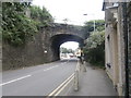
Railway bridge over Llangyfelach Rd, Swansea
Image: © John Lord
Taken: 24 Aug 2016
0.05 miles
9

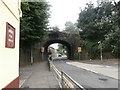
Railway underpass at the northern end of Mainwaring Terrace, Swansea
Boulders behind the camera prevent anything bigger than a motorbike from accessing this route,
which appears to have formerly been a through route, headroom 8 feet.
Image: © Jaggery
Taken: 6 Dec 2013
0.06 miles
10
Railway bridge over Llangyfelach Rd, Swansea
Image: © John Lord
Taken: 24 Aug 2016
0.06 miles