IMAGES TAKEN NEAR TO
Heol Nant Gelli, SWANSEA, SA5 9DU
Introduction
This page details the photographs taken nearby to Heol Nant Gelli, SA5 9DU by members of the Geograph project.
The Geograph project started in 2005 with the aim of publishing, organising and preserving representative images for every square kilometre of Great Britain, Ireland and the Isle of Man.

There are currently over 7.5m images from over14,400 individuals and you can help contribute to the project by visiting https://www.geograph.org.uk
Image Map
Images are licensed for reuse under creativecommons.org/licenses/by-sa/2.0
Notes
- Clicking on the map will re-center to the selected point.
- The higher the marker number, the further away the image location is from the centre of the postcode.
Image Listing (28 Images Found)
Images are licensed for reuse under creativecommons.org/licenses/by-sa/2.0
Image
Details
Distance
1
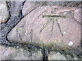
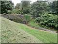
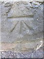
Ordnance Survey Cut Mark
This OS cut mark can be found on the wall of Cwmgelli Cemetery, NW of Heol Gerrig. It marks a point 66.523m above mean sea level.
Image: © Adrian Dust
Taken: 22 Jan 2014
0.05 miles
2
Ruin of former stores at Cnap Llwyd
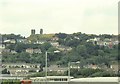
Only 2 corners of masonry remain from this building high on wasteland. This is the view south out to Swansea Bay.
Image: © Nigel Davies
Taken: 31 Jul 2005
0.07 miles
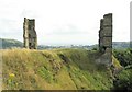
3
Ruin on Cnap Llwyd, seen from below
The odd corner ruins look like mysterious towers from a distance.
Image: © Nigel Davies
Taken: 31 Jul 2005
0.07 miles
6
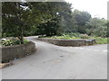
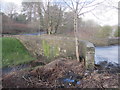
Pont Cwmgelli Bridge
Pont yn rhychwantu Nant y Gelli ger Cnap Llwyd.
A bridge spanning Nant y Gelli Stream near Cnap Llwyd.
Image: © Alan Richards
Taken: 15 Mar 2014
0.08 miles
7
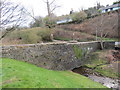
Ordnance Survey Cut Mark
This OS cut mark can be found on the NE parapet of Pont Y Shoot. It marks a point 56.921m above mean sea level. http://www.geograph.org.uk/photo/3823493
Image: © Adrian Dust
Taken: 22 Jan 2014
0.08 miles
8
Pont Y Shoot
There is an Ordnance Survey cut mark on the NE parapet. http://www.geograph.org.uk/photo/3823453
Image: © Adrian Dust
Taken: 22 Jan 2014
0.08 miles