IMAGES TAKEN NEAR TO
Moriah Road, SWANSEA, SA5 9BU
Introduction
This page details the photographs taken nearby to Moriah Road, SA5 9BU by members of the Geograph project.
The Geograph project started in 2005 with the aim of publishing, organising and preserving representative images for every square kilometre of Great Britain, Ireland and the Isle of Man.

There are currently over 7.5m images from over14,400 individuals and you can help contribute to the project by visiting https://www.geograph.org.uk
Image Map
Images are licensed for reuse under creativecommons.org/licenses/by-sa/2.0
Notes
- Clicking on the map will re-center to the selected point.
- The higher the marker number, the further away the image location is from the centre of the postcode.
Image Listing (6 Images Found)
Images are licensed for reuse under creativecommons.org/licenses/by-sa/2.0
Image
Details
Distance
1
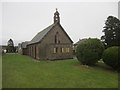
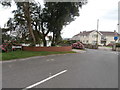
St Alban's Church Hall
Set back on Llangyfelach Road.
Image: © Adrian Dust
Taken: 23 Jan 2014
0.08 miles
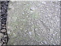
2
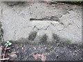
Ordnance Survey Cut Mark
This OS cut mark can be found on the wall of No704 Llangyfelach Road. It marks a point 100.026m above mean sea level.
Image: © Adrian Dust
Taken: 23 Jan 2014
0.10 miles
3
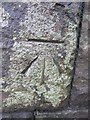
Ordnance Survey Cut Mark
This OS cut mark can be found on the entrance to Cwmgelli Cemetery. It marks a point 87.837m above mean sea level. http://www.geograph.org.uk/photo/3822455
Image: © Adrian Dust
Taken: 22 Jan 2014
0.17 miles
4
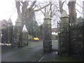
Cwmgelli Cemetery Entrance
There is an Ordnance Survey cut mark on the right hand pillar. http://www.geograph.org.uk/photo/3822453
Image: © Adrian Dust
Taken: 22 Jan 2014
0.17 miles
6
Ordnance Survey Rivet
This OS rivet can be found on the top step, SE side of Heol Gwyrosydd. It marks a point 136.099m above mean sea level.
Image: © Adrian Dust
Taken: 23 Jan 2014
0.22 miles