IMAGES TAKEN NEAR TO
Middle Road, SWANSEA, SA5 8EH
Introduction
This page details the photographs taken nearby to Middle Road, SA5 8EH by members of the Geograph project.
The Geograph project started in 2005 with the aim of publishing, organising and preserving representative images for every square kilometre of Great Britain, Ireland and the Isle of Man.

There are currently over 7.5m images from over14,400 individuals and you can help contribute to the project by visiting https://www.geograph.org.uk
Image Map
Images are licensed for reuse under creativecommons.org/licenses/by-sa/2.0
Notes
- Clicking on the map will re-center to the selected point.
- The higher the marker number, the further away the image location is from the centre of the postcode.
Image Listing (18 Images Found)
Images are licensed for reuse under creativecommons.org/licenses/by-sa/2.0
Image
Details
Distance
1
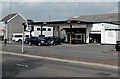
Hertz car hire, Gendros, Swansea
Located in Ael y Bryn Service Station, 790 Carmarthen Road in the Gendros area of Swansea.
Image: © Jaggery
Taken: 25 Sep 2013
0.15 miles
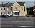
2
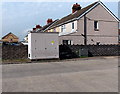
Brilliant Money in Swansea
Financial services business at 816 Carmarthen Road, on the corner of King's Head Road.
Image: © Jaggery
Taken: 25 Sep 2013
0.16 miles
3
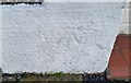
Ordnance Survey Cut Mark
This OS cut mark can be found on No738 Carmarthen Road. It marks a point 104.280m above mean sea level.
Image: © Adrian Dust
Taken: 20 Jan 2019
0.17 miles
4
64-BIT computing in Swansea
Located at 836 Carmarthen Road in the Cockett area of Swansea, 64-BIT computing provides business IT support and IT consultancy services for small and medium sized companies.
Image: © Jaggery
Taken: 25 Sep 2013
0.18 miles
5
Western Power Distribution electricity substation in Cwmdu Industrial Estate, Swansea
Located near the corner of Carmarthen Road. The identifier on the box shows CWS Fforest Fach S/S.
Image: © Jaggery
Taken: 25 Sep 2013
0.19 miles
6
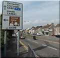
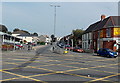
Next left for the Gower, Swansea
The signpost is alongside the A483 Carmarthen Road near the Bryn Road junction.
The left turn for the Gower (peninsula) is into the A4216 Station Road.
Image: © Jaggery
Taken: 25 Sep 2013
0.19 miles
7
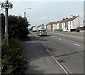
Carmarthen Road houses in the Gendros area of Swansea
The sign on a lamp post shows that this is the A483.
Image: © Jaggery
Taken: 25 Sep 2013
0.20 miles
8

Ordnance Survey Cut Mark
This OS cut mark can be found on the stone post of the Embassy Social Club. It marks a point 114.364m above mean sea level.
Image: © Adrian Dust
Taken: 20 Jan 2019
0.20 miles
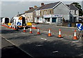
9
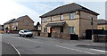
Brickyard Road Swansea
Viewed from the corner of Carmarthen Road.
Image: © Jaggery
Taken: 25 Sep 2013
0.20 miles
10
Ravenhill Road Swansea
Ravenhill Road heads NE into the Raven Hill district of Swansea,
away from Carmarthen Road in the Fforestfach district of Swansea.
Image: © Jaggery
Taken: 25 Sep 2013
0.20 miles